


|
||

|

|
|

|
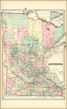
U.S.-Dakota War-Era Map of Minnesota.
Detailed map of Minnesota, colored by counties and showing towns, roads, railroads, rivers, lakes, and a host of other details. The northern counties are still quite oversized.
SA Mitchell Jr. acquired his father's former business from DeSilver in 1860 and relaunched a very successful atlas publishing business which survived another 20+ years, before licensing and selling off much of his inventory and rights.
Samuel Augustus Mitchell Jr. inherited the Mitchell Company from his father in 1860. For over thirty years, the company had specialized in the production of school atlases and wall maps of America. They were one of the pioneers on engraving on steel plates. In 1860, Samuel Jr. released the New General Atlas, which had been compiled in house and replaced a previous atlas by Tanner. The elder Mitchell died in 1868 and Samuel Jr. continued the business until the 1890s. At its height, the Mitchell Company employed 250 people and sold 400,000 publications annually.

![[ Map of the Mississippi River ]](https://storage.googleapis.com/raremaps/img/small/99811.jpg)
