


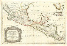
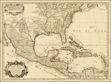
|
||

|

|
|

|
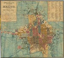
Exacting Map of the Distrito Federal of Mexico
Detailed map of Mexico City and the Distrito Federal in central Mexico.
At this time, the D.F. had not been fixed with its modern borders and consisted of five districts: México, Guadalupe Hidalgo, Tacubaya, Tlalpam, and Xochimilco. The map stretches from the cerros in the west to the lakes of the east of the region.
According to the key at the upper right, the map shows cities, towns, neighborhoods, haciendas and ranches, municipal and district seats, woods, and factories. Also marked are large roads and railroad lines, the latter of which were being heavily developed during the time of this map’s creation.
In addition to the legend are four informative tables that dot the map’s margins. To the right, below the key is a smaller inset map. This shows the political divisions in the state, along with the municipalities of each district. Just below, another table tells the reader how many people lived in each district during 1874. To the let is an abbreviation table, a set of notes, the geographic coordinates of prominent points of interest, and a topographic chart that lists important references for the map.
Larger cities are shown in plan view, with each street and plaza visible. The largest of these is Mexico D.F., or Mexico City, which was beginning to sprawl when this map was made. The city is the oldest capital in the Americas and one of two founded by Indigenous peoples (the other is Quito). It was originally called Tenochtitlan and served as capital to the Mexica people. Then, the Aztecs used it as their capital until they were conquered by the Spanish in 1521.
The map was made under the leadership of Agustín Díaz, an accomplished military engineer and surveyor.
Agustín Díaz was a Mexican surveyor, cartographer, and administrator. Trained as a military engineer, Díaz was a skilled surveyor. From 1850-7, he was an integral part of the Mexican surveying team involved in the Comisión Mexicana de Límites con los Estados Unidos following the Mexican-American War. Under the Emperor Maximilian (1864-7), he led a scientific expedition to the Yucatan. He also taught geography at the Colegio Militar, a school he had also attended as a young man. In 1877, Díaz was named head of a cartographic commission that reviewed the state of Mexico’s maps and plans. He found it woefully inadequate and recommended a complete overhaul. His proposal was taken up and he was named head of the newly-created Comisión Geográfico-Exploradora. The CGE was supposed to create a master map of the Republic at a scale of 1:100,000. He served at the CGE until his death in 1893.


![(Humboldt Atlas and Text) Geographique et Physique du Royaume de Nouvelle-Espagne [with quarto text:] Essai Politique de la Royaume de la Nouvelle-Espagne](https://storage.googleapis.com/raremaps/img/small/99796.jpg)