


|
||

|

|
|

|
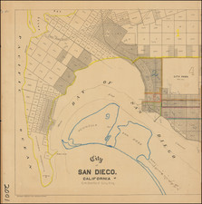
The First Atlas Map of Del Mar, California
Centered on the Stratford Inn and the Old Del Mar Pier, the map provides a fine town plan of Old Del Mar and recent additions.
The map is oriented with east at the top and extends north to 24th Street and south to 9th Street.
At the center is the newly constructed Del Mar Pleasure Pier, constructed by the owners of the Stratford Inn, along the old Bathhouse and Power House. The Der Mar Train station across the road.
This is from W.E. Alexander's 1912 Plat Book of San Diego County, California published by the Pacific Plat Book Company of Los Angeles and San Francisco.
Der Mar
On August 14, 1882, the first California Southern Railroad train went over the tracks on its new route from San Diego to San Bernardino. Theodore M. Loop, a contractor and engineer who worked on the project, built a home on a mesa just North of the City of San Diego, a setting he described as “the most attractive place on the entire coast.” Loop built a tent city on the beach and his wife, Ella, called it “Del Mar,” based upon a popular poem, The Fight on Paseo Del Mar.
In 1885, Del Mar was established, when Colonel Jacob Taylor purchased 338 acres from Enoch Talbert, with visions of building a seaside resort for the rich and famous.
Stratford Inn
In 1909 William G. Kerckhoff and the South Coast Land Company opened the large Stratford Inn in Del Mar. Later called the Del Mar Hotel, it was a world-class hotel that eventually would become a magnet for Hollywood stars. Among the hotel’s amenities were a salt-water swimming pool (the Plunge), a bathhouse, golf course, and a “pleasure pier” that was constructed in 1909. The plunge and pier were the main attractions.
Del Mar Pier
Constructed in 1909, the Del Mar Pier (also known as the 15th Street Pier) was 1,000 feet long and originally designed to be used by hotel guests. At the end of the pier was a pump house that was used to pump seawater into the “Plunge.” The pier was a popular haunt and provided, according to early records, “superb fishing.” A newspaper ad dated January 1, 1917 reported: “the thousand-foot pier, where the gamiest fish, weighing from one to thirty pounds, are caught is a great attraction to the man with rod and reel.”
It would be severely damaged and rebuilt several times before its final demise in 1957.
Rarity
In over 25 years of business in San Diego, this is the first time we have offered the map for sale.
Separate maps of Del Mar are almost unheard of in the antiquarian map market.
![[ Southern California Tourism ] Hunting and Fishing in Southern California on the Santa Fe](https://storage.googleapis.com/raremaps/img/small/101613.jpg)
![(San Diego) [Set of sixteen early aerial photographs of San Diego]](https://storage.googleapis.com/raremaps/img/small/95394.jpg)