|
||

|

|
|

|
Alexander Dalrymple Commands A British East India Company Factory
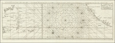
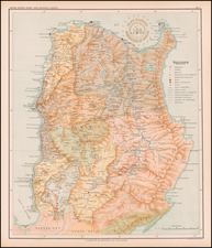
Fine English sea chart, covering the southern-most part of the Palawan Province in the Philippines and Balambangan Island (Malaysia), north of Borneo.
The present chart has a fascinating historical context, with Balambangan Island being the site of an English East India Company Factory which was led by two of England's most famous chartmakers, Alexander Dalrymple and John Herbert, both of whom were relatively swiftly terminated, Dalrymple for being disagreeable and Herbert for mismanagement. This would not be Dalrymple's last assignment which would be marred by his "quarrelsome" nature. His disagreements with Henry Roberts and James King regarding the editing of the maps and text for the official account of the third voyage of James Cook are described at length by Helen Wallis.
The map shows a portion of Borneo's north coast along with the nearby islands, with a large inset map of Balambangan Island. The map notes soundings and coastal features, with minimal interior detail. Alexander Dalrymple explored the East Indies in the employ of the East India Company. This map shows the track of his ship during the 1762 journey.
The map appeared in The East India Pilot: a collection of charts, maps and plans for navigation, London: Published according to Act of Parliament by Alexander Dalrymple, Novr. 30, 1770. It would also be included in French naval atlases, sometimes with the added embossed image of the French Hydrographical Society.
Balambangan Island
During his time at sea, Alexander Dalrymple, as an officer of the British East India Company, concluded an agreement with Sultan Bantilan Muizzud-Din on September 12, 1762 whereby the Sultanate of Sulu ceded the island of Balambangan to East India Company. Dalrymple took possession of the island on January 22,1763.
The East India Company thereafter established a factory on Balambangan in 1768 and Dalrymple was offered the role of management of the new settlement. However, Dalrymple quarreled with the directors, and his insistence on absolute management of Balambangan led to his dismissal in March 1771.
Dalrymple was replaced by John Herbert who commanded the Britannia as it transported soldiers, goods, and supplies from India in 1772, and arrived at Balambangan in December 1773.
The British East India Company settlement traded opium, munitions, and fabrics with the Tausugs and Maguindanaons. Herbert's mismanagement of Balambangan and poor relations with the Tausugs resulted in the settlement's destruction on February 1775 at the hands of Moro pirates, and Herbert and other survivors escaped to Brunei.
In the second half of the 18th century, the Dutch from Batavia attempted to settle the island's western coast, but withdrew by 1797.
Alexander Dalrymple (1737-1808) was a skilled hydrographer. He was born near Edinburgh and was the son of a Member of Parliament. As a teenager, Alexander—the eleventh of fifteen children—began a career with the East India Company (EIC). He worked as a writer for the Company and was posted to Madras in 1753. There, he rose to the position of sub-secretary and researched the English trade with Burma, Indo-China, and Borneo, quickly becoming an expert in Maritime Southeast Asia.
While a Company servant, Dalrymple sailed on three voyages around the Philippines, Borneo, Sulu, and other islands. He was testing hydrographic hypotheses, accessing archives, and making new charts on all of these voyages. In 1763, he resigned from the EIC and began a return trip to London, where he sought to promote a new trading opportunity at Balambangan. On his way home, he was named provisional deputy governor at Manila in April 1764, as the British then held the archipelago.
Back in London, Dalrymple continued to research the geography and hydrography of the South Seas and the East Indies. He published several works, including An Account of the Discoveries Made in the South Pacifick Ocean Previous to 1764 (1767) and An Historical Collection of the Several Voyages and Discoveries in the South Pacific Ocean (1769-71). The former of these made him the Royal Society’s preference to lead the South Pacific leg of the Transit of Venus observations of 1769; the Admiralty preferred a naval officer and chose Lieutenant James Cook instead. In both of these works, Dalrymple championed the hypothesis that there was a massive southern continent counterbalancing the northern continents.
Dalrymple also published many charts at this time, and he continued to lobby for a trade settlement at Balambangan. However, a disagreement with the EIC meant that he was removed from the proposed expedition to the island. In 1774, he began to publish his series of Plans of Ports in the East Indies, complete with sailing directions. Thanks in part to this successful venture, he managed to regain employment with the EIC in 1775, returning to Madras. There, he was ensnared in a scandal involving the Madras council which necessitated his return to London in April 1777.
On the return voyage, Dalrymple used a John Arnold chronometer and became an advocate for renewed and precise calculation of longitude to both signal the best routes during the proper seasons and to revise charts. He convinced the EIC to employ him on correcting their charts and publishing new ones, which he began to do in 1779. In the same year, he proposed a project that would create coastal charts for EIC ships from the Mozambique Channel to China. To this end, Dalrymple began publishing new charts annually. In fifteen years, Dalrymple published 550 plan and charts, 45 plates of coastal views, and nearly sixty books and pamphlets on navigation.
A Fellow of the Royal Society since 1771, Dalrymple was at the heart of a large circle of savants interested in geography. He was a close friend of Joseph Banks, James Rennell (with whom he had sailed in the East Indies), and William Marsden. Dalrymple contributed to the compilation of charts for the Vancouver expedition in the early 1790s, just one sign of his close relations with various branches of the government and the elite.
In 1795, his skills, erudition, experience, and social ties led him to be named as the first head of Britain’s newly-created Hydrographic Office (HO). His main task at this time was to sort the existing chart collection, while also evaluating the charts’ continued utility. By 1800, the HO was also tentatively engraving their own charts, although not performing their own surveying expeditions. While at the HO, Dalrymple proofed over 150 charts, as well as reprinted many of this own EIC plates, which by 1804 numbered 817. In 1806, Dalrymple published his EIC charts and sailing directions together in geographically-themed volumes, the Collection of Nautical Memoirs and Journals.
Things were not all rosy, however, as Dalrymple clashed with officials at the Admiralty over confidentiality of unpublished foreign charts and the direction of the HO. The Board of Admiralty fired him in late May of 1808. He died only three weeks later, on June 19, 1808.
In addition to the hundreds of charts he created in his lifetime, his personal working library was considerable. This library went on to form the core of the Admiralty library and of the HO’s own book collection. The Admiralty also bought over 400 of his copper plates, many of which were re-issued as Admiralty charts.
![[Northern Borneo / Palawan Province ] To His Majesty George the Third, King of Great Britain, &c. This Chart of Felicia, and Plan of the Island Balambangan is humbly presented By His Majesty's faithful Subject, Dalrymple](https://storage.googleapis.com/raremaps/img/small/71752.jpg)