|
||

|

|
|

|
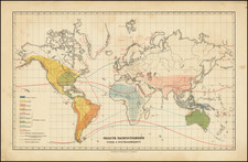
Striking World Map Illustrating Global Shipping—With Manuscript Annotations!
Fine large map of the world on Mercator's projection, published in Gotha by Justus Perthes.
Centered on the Atlantic, the map provides a remarkable look at the shipping lanes, ocean currents and seasonal details essential for oceanic transit between the continents. It illustrates the importance of expanded global maritime trade facilitated by rapid improvements in steam-powered vessels and increasingly open markets in Asia.
The sheer density of information shared on this map is striking. A legend in the lower right explains a dizzying array of details that are marked on the main map. Accompanying this is an abbreviation key in the top right.
There are symbols for types of oceanic drift, i.e. the currents, as well as the extents of coast and polar ice and the spread of sargasso seas, or kelp and seaweed. Another set of symbols indicates the type of sea bottom a ship might encounter, navigational obstructions (rocks, shoals, reefs, etc.), and types of inland waterways (lakes, lagoons, swamps, rainbeds, cataracts and rapids, and canals).
One of the currents is the “Ku Ro Siwo,” or the Black Stream. The Kuroshio Current is a north-flowing current of warm water. It serves as a western boundary current in the Pacific, much as the Gulf Stream does in the Atlantic, and forms the west side of the clockwise North Pacific Ocean gyre. It is called the Black Stream due to the deep blue of the waters and is known for being treacherous to navigate, although a canoe team recently recreated an ancient migration route thought to follow the stream.
Also filling the waters are shipping and steamer routes, split into type by their frequency. A long list of steam navigation companies—carrying goods, the post, and people---are ordered by their areas of operation. The nationality of the owners of the steam packets are color-coded.
There are also tracks of sailing vessels, mostly in the Arctic. These include the tracks of the voyages sent in search of the lost Franklin expedition, such as that of Horatio Austin in command of HMS Resolute.
The land is not neglected, however. There are gradations of color that indicate the type of “Continental Surface.” These range from glaciers to deserts to woodlands. Imperial and national boundaries are marked with dotted lines and rivers and hachured mountains are prominent.
In addition to the main map, there are a series of inset maps that offer higher-resolution or thematic depictions of certain areas. In the upper right are the approaches to Shanghai and Yokohama (Yedo Bay). In the lower right is a general chart of the world highlighting the major wind patterns. Next to this are insets of Canton, the Sunda Strait, Singapore, and the Cape of Good Hope.
In the lower left is a polar projection of the world in two hemispheres; it includes global telegraph lines. There is also a world map showing the lines of magnetic declination. Interspersed between these are insets of the Virgin Islands, Rio de Janeiro, Honolulu, Auckland, and Port Phillip with Melbourne.
In the upper left corner are still more insets. These are the Isthmus of Tehuantepec, the proposed Nicaragua Route over Central America, the Isthmus of Panama, Honduras Bay, the Isthmus of Darien, San Francisco, New York, and Portsmouth and Southampton.
This last set of insets suggest an intense interest in a shorter route from Atlantic to Pacific. The Panama Canal would not be completed until 1914, but ideas for routes overland were in the works for decades prior to this. One of these is the “Nicaragua Route” shown here. However, Lake Nicaragua is an important freshwater source for Central America and the route was never constructed.
The final insets are tucked into Greenland. These show the west and east ends of the Atlantic telegraph cables. Below them is a map showing Lower Egypt, or the Nile River Delta.
Manuscript additions
This example has manuscript additions in a contemporary hand. They show that the map was used for navigation; there are also tack marks in the upper corners that indicate it was consulted while mounted on a surface, likely a wall, for part of its history.
A route line is marked from Buenos Aires headed east. It crosses the Atlantic and rounds the Cape of Good Hope, hugging the coast. The routes shows a ship’s position on the voyage, which started on March 28 and lasted until April 18, 1881. Various symbols are added to this route line that indicate events like “set south of course,” “set east of log,” and “set north.” A note in the lower margin, below the neatline, explains, “28 Mch to 6th April 9 days heavy weather, with lull in force of wind on 7th day. Worst on 8th day.”
Although published in Gotha, this map was sold by Thomas Letts, who operated a store in London. Letts was an authorized vendor of Ordinance Survey maps and also stocked items from other prominent map publishers like Justus Perthes. Letts’ plate is also on the pocket accompanying the map.
Berghaus first issued this map in 1863. It was revised numerous times, with editions known as late as 1897. This is a seventh edition, published in 1873.
![[ World ] Air France -- Sur Les Ailes D'Air France Decouvrez Le Monde A Votre Tour](https://storage.googleapis.com/raremaps/img/small/100053.jpg)
![[Early Facsimile] Carta Marina Navigatoria Portugalien Navigationes: atque tocius cogniti orbis terrae marisque formae naturam situm et terminos noviter recognitos et ab antiquorum traditione differentes hec generaliter monstrat, 1525](https://storage.googleapis.com/raremaps/img/small/66533.jpg)
![A General Atlas Containing Distinct Maps Of all the known Countries in the World. Constructed from the Latest Authority [Binder's title: Lucas's Cabinet Atlas]](https://storage.googleapis.com/raremaps/img/small/80266.jpg)