This item has been sold, but you can enter your email address to be notified if another example becomes available.


|
||

|

|
|

|
Stock# 71747
Description
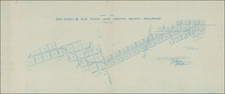
The First Atlas Map of South San Diego County, California
The map provides a fine depiction of Chula Vista, Imperial Beach, Otay and San Ysidro, extending to the Tijuana Estuary.
The vast majority of lands are identified with the names of the land owners. The lines of the San Diego and Southern Rail Road and San Diego and Arizona Rail Road are shown.
This is from W.E. Alexander's 1912 Plat Book of San Diego County, California published by the Pacific Plat Book Company of Los Angeles and San Francisco.
Rarity
In over 25 years of business in San Diego, this is the first time we have offered the map for sale.