
This item has been sold, but you can enter your email address to be notified if another example becomes available.


|
||

|

|
|

|
Stock# 71722
Description
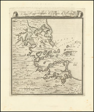
Rare Early 19th-Century Boston Harbor Chart.
A fine example of John Luffman's rare map of Boston Harbor, published in London in 1802.
The map extends from the Atlantic Ocean into Boston Harbor showing the famous peninsular configuration before the substantial infill of the 19th and 20th centuries.
Roxbury, Dorchester, "Charles Town", and Winsimit are all indicated.
The text at the bottom notes:
Boston, the Capital of the State of Massachuset in North America, the Streets are handsome & the Harbor spacious.
Rarity
Maps by John Luffman are very scarce on the market, this being the first time we have had this one.
Condition Description
Original hand-color.
![[Boston Harbor and Environs] Coast Chart No. 9 Boston and Approaches . . . Massachusetts Bay with the Coast from Cape Ann to Cape Cod . . . 1872](https://storage.googleapis.com/raremaps/img/small/90721.jpg)
![[Harvard] Universita di Cambridge](https://storage.googleapis.com/raremaps/img/small/88045.jpg)