


|
||

|

|
|

|
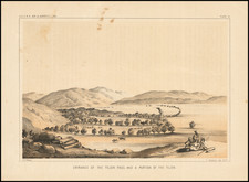
[Chavez Ravine / Cathedral High School] The United States Confirms Ownership of the Calvary Cemetery and Lands of Owned by Los Angeles' First Catholic Church in Chavez Ravine
An early California rarity!
Finely executed survey map, which accompanied the final deed granting to the Catholic Diocese the land adjacent to the Calvary Cemetery which belonged to La Pacita, La Iglesia de Nuestra Señora la Reina de los Ángeles, the first Catholic Church in Los Angeles.
The map is contemporary copy of the original hand drawn map which was presented by the Mayor of Los Angeles, John G. Nichols, to Fra. Blasius Raho at the time that ownership of the lands was officially confirmed to the Roman Catholic Church in 1857.
The map shows the area centered on the 10 acre tract in the southeastern corner of Chavez Ravine, then (and still) owned by the Roman Catholic Diocese (now the location of Cathedral High School and St Peter's and St. Bridget Catholic Churches), with Eternity Street on the east side of the tract. While the church had owned these lands since the establishment of the Church in the Spanish California Pueblo of Los Angeles in 1781, the present map was prepared to accompany the deed which granted title to the land following annexation of California by the United States. The Treaty of Guadalupe Hidalgo, which ended the war with Mexico in 1848, required that landowners claiming title under Spanish and Mexican land grants would be respected. A process for proving land ownership was established by Congress in 1851. It would take another 5 years, until 1856, for the lands to finally be confirmed to the Church, with the deed (and this accompanying map) being issued thereafter by the Mayor of Los Angeles, transferring title to B. Raho (Fra. Blasius Raho), who had just arrived from Santa Barbara to serve as pastor of the Church.
The map includes 3 separate certifications:
- Adolphus Waldemar, Deputy County Surveyor, Los Angeles County: Certifying on March 3, 1857 that the map is a copy of the survey executed by Waldemar on February 28, 1857 at the request of John G. Nichols, Mayor of Los Angeles City.
- John G. Nichols, Mayor: Acknowledging that the property shown was deeded on April 17, 1857 by the City of Los Angeles
- John W. Shore Recorder / JA Hinchman Deputy Recorder for Los Angeles County: Acknowledging recording of the deed of [Reverend Friar] B[lasius] Raho on April 22, 1857.
When Los Angeles was originally surveyed and mapped under the leadership of General Edward Ord in 1849, its graveyard was at the upper end of Eternity Street (illustrated as the cemetery on this map). At the lower end of Eternity was the first church in Los Angeles, La Placita. In between lay a part of town flanked by adobe houses, citrus trees, and Coast Live Oaks suitable for traditional funeral processions escorting believers to eternity. The land allotted to the cemetery lay between a creek a half block north of College Street and the toma (intake of the Zanja Madre) beyond the northern edge of town.
All the important resident of the area around Los Angeles were buried at Calvary, such as General Andrés Pico, the hero of the Battle of San Pascual, and Don Abel Stearns. The ravine sloping down from the west took its name; at the time it was called "Cemetery Ravine" (now Chavez Ravine, home of Dodger Stadium).
La Iglesia de Nuestra Señora la Reina de los Ángeles
La Iglesia de Nuestra Señora la Reina de los Ángeles ("The Church of Our Lady Queen of the Angels") was founded on August 18, 1814, by Franciscan Fray Luis Gil y Taboada. Fra. Gil y Taboada placed the cornerstone for the new church in the adobe ruins of the original "sub-station mission" here, the Nuestra Señora Reina de los Ángeles Asistencia (founded 1784), thirty years after it was established to serve the settlement founding Los Angeles Pobladores (original settlers). The completed new structure was dedicated on December 8, 1822. A replacement chapel, named La Iglesia de Nuestra Señora de los Ángeles – for Mary, mother of Jesus or "The Church of Our Lady of the Angels" – was rebuilt using materials of the original church in 1861. For years, the little chapel, which collected the nicknames "La Placita" and "Plaza Church," served as the sole Roman Catholic church in Los Angeles.
El Campo Santo
El Campo Santo shown on the map was the cemetery of the church. While the church was established in 1781, for the first 40 years of Los Angeles’s existence, departed citizens were buried in the graveyards of Mission San Gabriel,or Mission San Fernando. With the consecration of La Iglesia de Nuestra Señora la Reina de Los Angeles, the Catholic church commonly known as La Placita in 1822, a new burial site was created. The first burials, in 1823, occurred along the northern church wall. After a few years, a new graveyard, referred to as Campo Santo and the Old Cemetery, was started on the southern side of the church.
About 695 Angeleno settlers were buried in the churchyard between 1823 and 1844. The site was used until November 1844, when a new Catholic cemetery, known as Calvary, was first used.
John Blasius Raho
Italian born Rev. Father Blasius, or John Blaise Raho, C.M., V.G., was a Catholic priest of the Congregation of the Mission of St. Vincent de Paul. He served as the Vicar General of the Diocese of Monterey and Los Angeles under fellow Vincentian Bishop Thaddeus Amat from 1855 until his death in 1862, age 56.
Ordained to the priesthood in 1832 from St. Mary's of the Barrens Seminary at Perryville, Missouri, Fr. Blas was a founding pastor of St. Patrick's Church in La Salle, Illinois, in 1838, and he was said to have known the future president, Abraham Lincoln. Known as the "Apostle of Central Illinois" for his wide travels and missionary zeal, he also served in Missouri, where he was the president of St. Louis Theological Seminary in 1845, and as a missionary priest in Mississippi and Louisiana, where he was the pastor at Lafourche.
Upon coming to California, he first ministered in Santa Barbara at Our Lady of Sorrows Church, and was then named pastor of La Placita, La Iglesia de Nuestra Señora la Reina de los Ángeles in Los Angeles in 1857. A beloved priest of the community, Fr. Blas was responsible for the growth of the diocese throughout Southern California.
Rarity
The map is apparently unrecorded.
![[Jefferson's Notes on the State of Virginia] Observations sur la Virginie [with the map:] A Map of the country between Albemarle Sound, and Lake Erie, comprehending the whole of Virginia, Maryland, Delaware, and Pensylvania, with parts of several other of the United States of America. Engraved for the Notes on Virginia.](https://storage.googleapis.com/raremaps/img/small/51828.jpg)
![(Los Angeles Architecture) [Photograph of a 1920s Spanish Colonial Revival home, likely in the Hollywood Hills area; with glass plate negative]](https://storage.googleapis.com/raremaps/img/small/96755.jpg)