|
||

|

|
|

|
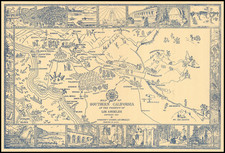
1858 Manuscript Map of the Los Angeles Area -- A Foundational Map of the San Fernando Valley
Incredible early manuscript showing Los Angeles, representing the first recorded fully surveyed map that extends from the nascent city of L. A. northwest to the San Fernando Mission.
The map focuses on roads and includes a large amount of ephemeral detail, with rancho buildings and important early Californian sites marked. This map was made by Henry Hancock, the famous early Los Angeles surveyor, and represents one of the handfuls of regional maps he produced. This is perhaps the most important map of the San Fernando Valley from the period, representing its early connections to a still-tiny Los Angeles.
Detail on the map is simply remarkable and offers an unparalleled insight into the early organization of the town. The region is divided into townships, formed of tessellated six-mile squares, with a numbering system giving their location respective to the San Bernardino baseline and meridian. Primary features shown include the roads to Los Angeles from the San Fernando Valley, connected by the extension of the valley east of the Santa Monica Mountains, as well as a shortcut through the Cahuenga Pass.
The survey records the borders of several ranchos, including Rancho Providencia Cahuenga, Rancho San Rafael, and the Tujunga Rancho. Township and range lines are also depicted. Cahuenga House and Old Mission Cavanza are depicted in the vicinity of Studio City.
The map is perhaps most notable for its treatment of roads. Surveys in the 1850s show different iterations of road mappings, with even Hancock's own other maps from the period contradicting each other on the layout and paths of roads, suggesting that optimal routes were still being developed. Further, this is the first-known of his maps to show a complete set of roads in the San Fernando area. This map preserves a trove of information that would be soon overwritten with the growth of American Los Angeles.
The map was produced by Henry Hancock, who served as surveyor for the city of Los Angeles shortly after its incorporation. He was instrumental in delineating the city following the concession of land from the United States Land Commission in 1856, which resulted in his Map of the city of Los Angeles, Showing the Confirmed Limits (1857), limited to the square shown on the presented map. Following this, his work expanded to survey areas outside the city, and in 1857-1860 he produced a number of plats of specific Ranchos, primarily for specific landowners. In 1858, the year of publication of this map, he was elected to represent California's First District in the state assembly, although this does not appear to have slowed down his surveying.
The scale given on the map is eighty chains to one inch (with one chain equal to sixty-six feet, thus eighty chains representing one mile), referring to a common surveying tool.
Primacy
This map is apparently unknown to Harlow in any form and is not mentioned in his Maps and surveys of the pueblo lands of Los Angeles. The map is among the earliest surviving survey maps of the Los Angeles area, along with another Henry Hancock sketch map in the collection of the Huntington Library. This undated sketch map is likely earlier, but shows a substantially more limited area and does not extend anywhere close to the San Fernando Mission. We were unable to locate any earlier surveys which showed the present area but also extend to Los Angeles.
Manuscript maps of Los Angeles prior to 1880 are very rare, and those prior to 1860 are even more so, representing the earliest days of any precise surveying in the city and surrounding regions. In addition, the majority of maps that have survived show only certain ranchos. Out of the thirty-two manuscript plans ascribed to Henry Hancock (probably the most prolific surveyor of this period) that we were able to trace, only four others focus on Los Angeles or are more complex than a simple plat of a rancho. This is the only map by Hancock we were able to locate which shows such a vast extent.
The Oak Tree
North of the "Old Mission" and the "Road to Los Angeles" is an "Oak Tree." This is almost certainly the Oak Tree which shows the location of "Station 39," used by Henry Hancock in his survey of the Rancho Ex-Mission San Fernando. This tree appears to be used to mark the location of the dogleg in the eastern border of the Rancho-Ex Mission. The use of transient features such as this one likely dates to the Mexican or Spanish period of Los Angeles and this tree was likely mentioned in the 1846 delimitation of the Rancho. Later surveys would have formalized the location of the boundary, using a reference to the San Bernardino Baseline, established in 1852.
Campo de Cahuenga
The map shows the Campo de Cahuenga (on this map "Cahuenga House") near the fork of the roads north of the Cahuenga Pass. This is where the famous Treaty of Cahuenga was signed between Major John Fremont and Andres Pico, ending hostilities between Mexico and the United States in 1847.
The Campo would later become a stage on the Butterfield Stage route, which first arrived in the area in 1858, the year this map was made. This company carried passengers and mail from Memphis and St. Louis west to San Francisco, taking a southerly route that swung through Los Angeles.
Near the Campo de Cahuenga, on the Los Angeles River, a dam is denoted. This is located downriver of the present-day Sepulveda Dam, approximately where West Olive Avenue crosses the river. This may have proved an opportune place to dam the river as it here passed near to the San Fernando Mountains, possibly leading to conducive, deeper-water hydrography. This map was produced nearly contemporaneously with the redevelopment of the Zanja system which had supplied Los Angeles with water for seventy years. In 1857, updates to the water reservoir were carried out that allowed for a storage system to be developed in the pueblo of Los Angeles. The first major reservoir would appear in 1869 as the Buena Vista Reservoir in Elysian Park. We were unable to trace other references to this dam.
Rancho Ex-Mission San Fernando
The map delimits the Rancho Ex-Mission in the upper left portion of the map, which represents the lands that had been devolved away from the mission by the Mexican government. The Rancho was sold to the de Celis family, and represented the single largest land grant in California. This grant was bought in part by the Pico family in 1853, and eventually passed to the Lankershim and Van Nuys real estate moguls.
In the same year that the presented map was produced, Hancock also made a detailed plat of the Ex-Mission. This would have extended detailed surveying far to the northeast, and it made sense for Hancock to produce another map that showed how Los Angeles and the valley were connected, a purpose which this map fulfills.
Hancock's 1858 Plat of the City Lands of Los Angeles. . .
The map was produced in the same year as, and likely relates to Hancock's 1858 Plat of the City Lands of Los Angeles finally confirmed to the Mayor and Common Council of the City of Los Angeles... an 1892 copy of which can be seen here. This map was critical to delimiting the bounds of the city of Los Angeles but does not extend its scope to outside of the city limits. As such, this map may have acted as a companion to the Plat, showing the lands where the previous map stops.
Regarding the previous map, Neal Harlow says:
[The area was] surveyed in September 1858 at the request of the Surveyor General of California under instructions from the General Land Office subsequent to the dismissal of appeals on February 2, 1858, by the U.S. District Court from the Southern District of California against the decision of the U.S. Land Commission of February 5, 1856. The plat, with varying notations and certifications, accompanied both the patents of 1866 and 1875. . . .
* * *
Hancock surveyed the boundary of the confirmed lands, connecting it with the grid system of the U.S. Public Land Survey. The map delineates a square, with little interior detail, only the north side deviating from a straight line where it follows the channels of the Los Angeles River and Arroyo Seco, beyond which lay private land. With the field notes, it was a guide to the boundaries as indicated by landmarks, posts, compass courses, and distances upon the ground. "Beginning at a post six inches square and four feet high marked 'C.L.A.,' at a point two hundred and ten chains and sixty-eight links south of the center of the plaza. Thence, according to the true meridian..." the boundary was meticulously and scrupulously traced and described around the square to the point of the beginning. The description of the one does not make exciting reading, but it fixed the limits of the Spanish pueblo, a decisive achievement in the development of the town. For the first time the authorities of Los Angles knew the city's extent, and the rancheros how far they could trespass and no farther.
Harlow, page 49:
Hancock advised the Common Council that the proper way for the City to proceed would be to petition the Land Commission to confirm the extent of "four leagues in every direction" and procure an order for a preliminary survey to be carried out at once under the direction of the Surveyor General, which would doubtless be adopted as final...
Henry Hancock was a Harvard trained lawyer and a land surveyor working in California in the 1850s. He was the owner of Rancho La Brea, which included the La Brea Tar Pits.
Hancock studied law at Harvard University. Graduating in 1846, he went St. Louis, Missouri, where he became a surveyor. During the Mexican–American War, he was quartermaster of the 1st Regiment Missouri Mounted Volunteers under Colonel Alexander William Doniphan. At the war's end, he returned home to New Hampshire but soon decided to go west.
Hancock travelled from Chicago to San Francisco, arriving in September, 1849, where he opened a law office. He briefly tried gold mining on American River, but in 1850 moved to Los Angeles.
Hancock engaged extensively in government surveying. Following California's annexation into the United States, the land grants given to Californios by the Spanish and Mexican colonial authorities were required to prove their claims to the new American government. Owners filed claims with the United States Land Commission and had to have their property surveyed and mapped by government surveyors.
Hancock was among the first and most prominent surveyors in Southern California. He served as Deputy Surveyor for the United States, but is better known for his work representing private claimants. He surveyed Rancho San Pedro for the Dominguez family, Rancho San Francisco for the Del Valles, Rancho San Jose owned by the Palomares and Vejar families; and Henry Dalton's Rancho Azusa de Dalton.
Hancock also served as the city surveyor for Los Angeles. He was first employed to do survey work for the city in 1853 to 1854.
On February 5, 1856, the United States Land Commission confirmed four square leagues of land to the City of Los Angeles (using 2.63 miles per league) with the center of the Plaza designated as the center of city land. As United States Deputy Surveyor, Hancock, surveyed the lands confirmed to the City by the United States Land Commission Patent of 1856.
In 1854, Hancock, along with Benjamin Davis Wilson, bought Rancho Rodeo de las Aguas. Hancock was elected to the California State Assembly as a Democrat, representing the 1st District from 1858 to 1860.
As a lawyer, Henry Hancock worked for the Rocha family to aid them with their efforts to prove their claim to Rancho La Brea. The Rochas finally won their claim, but like so many other Californios, their legal expenses left them broke. In 1860 Jose Jorge Rocha, the son of Don Antonio Jose Rocha, deeded Rancho La Brea to Henry Hancock.
During the American Civil War (1861–1865), when there was considerable Confederate sympathy in Southern California, Hancock sided with the Union. He became major of the 4th California Infantry Regiment and for a time was commanding officer of Camp Drum, established to guard against pro-Confederate activities near Los Angeles. He also was sent to Santa Catalina Island to survey it and chose the location for its Union garrison.
After the war, Hancock engaged in the commercial development of the asphaltum deposits on Rancho La Brea. He promoted its use for sidewalk and paving purposes, and shipped considerable quantities to San Francisco by schooner.
In 1863 Hancock married Ida Haraszthy (Ida Hancock Ross), the daughter of Agoston Haraszthy, the "Father of Modern Viticulture in California".
![Air Log Western Air Express [Los Angeles-San Diego, Las Vegas-Los Angeles, Milford-Vegas, Salt Lake City-Milford]](https://storage.googleapis.com/raremaps/img/small/85953.jpg)
![San Bernardino County [and:] Southwest Portion of San Bernardino County](https://storage.googleapis.com/raremaps/img/small/96727.jpg)