|
||

|

|
|

|
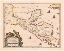
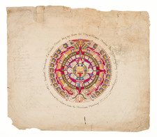
Scarce pair of maps of the Territories of Sierragorda and Isla del Carmen, from Antonio Garcia y Cubas' monumental Atlas Geographico, Estadistico e Historico de la Republica Mexicana, the first atlas of the Mexican Republic.
Garcia Cubas' maps of Sierragorda and Isla del Carmen are the earliest maps of these two territories. The surrounding text includes a wealth of information regarding Sierragorda and Isla del Carmen, including History, Climate, Agriculture, Minerals, Livestock, Commerce, Population and Itineraries.
Antonio Garcia y Cubas was Mexico's first great map maker and his work is highly sought after. This map shows the various regions within Guerrero, including, towns, roads, rivers, etc. Only 300 examples of the atlas were reportedly printed and separate maps rarely appear on the market.
Sierra Gorda
The Sierra Gorda is an ecological region centered on the northern third of the Mexican state of Querétaro and extending into the neighboring states of Guanajuato, Hidalgo and San Luis Potosí.
In the 19th century, the area was still heavily dominated by indigenous people, with small settlements of mestizos and criollos. The Sierra Gorda Rebellion began in 1847 by deserters from the Mexican army. The uprising spread to nearly all parts of the Sierra Gorda region from Guanajuato to San Luis Potosí to Veracruz, with the most activity in Santa María del Río, Xichú and Rioverde between 1847 and 1849. The rebels demanded free use of various lands, the abolition of levies, the division of haciendas and the termination of parish church rights to land. Initial efforts by authorities to subdue the uprising were only partially successful. Rebels had control of various cities such as Ciudad Fernández, Rioverde and Santa María del Río by 1849. However, the government caught the most important rebel leader by the name of Quiroz that same year and executed him. This broke the main resistance and the government was able to put much of the rebellion down by 1850.
From Jalpan, General Tomás Mejía led military actions here against the Liberal government installed in the state of Querétaro and the country. He managed to take the main square of Querétaro in 1857. However, at the end of the Reform War, he was executed along with Maximilian I of Mexico.
In 1880, the first major (dirt) road was built through the area to connect it with the capital. This spurred economic development in the region.
The Territory of Isla del Carmen
Once a haven for pirates, since the colonial era there was a dispute between Tabasco and Yucatán for the possession of the island of Carmen. In 1817, Tabasco owned the island of Carmen, Palizada and Sabancuy. However, the country's government did not have a clear idea of the geographical location of the island, to such an extent that Iturbide, by order of September 2, 1822, made El Carmen depend on the state of Puebla. But in 1823 the restored Mexican Congress wanting to correct this error, ordered to be reinstated in the jurisdiction of Tabasco "... adding the District of the Laguna de Términos" to the General Command of Tabasco Torruco Saravia. However, in August 1824, due to pressure from the Yucatán government, Carmen's territory was segregated from Tabasco to be incorporated into Yucatán.
In 1842, the governor of Tabasco Francisco de Sentmanat, decided to invade Yucatán and took Palizada and El Carmen, segregating them from the Yucatecan jurisdiction and reinstating them to the Department of Tabasco, however, when it was overthrown, the new governor José Julián Dueñas returned the territories to Yucatán. A few months later, Tabasco recovered the territory of El Carmen, when General Santa Anna decreed, on October 2, 1843, the pass of the El Carmen party to the jurisdiction of Tabasco. However, on July 15, 1854 the same general Antonio López de Santa Anna decreed the creation of the Territory of Carmen, with territory segregated to Tabasco and Yucatán, with which Tabasco was snatched almost the entire game of Usumacinta and the island of Carmen.
Later, on June 4, 1856, the governor of Tabasco José Víctor Jiménez sent a letter to the Constituent Congress of the Nation, raising his voice to request that his old limits be returned to Tabasco, "... to demarcate and extend the current limits of Tabasco with the states of Chiapas, Yucatán and Veracruz". On September 17, 1856, with 77 votes in favor by 8 against, there was the dissolution of the Territory of Carmen, recovering Tabasco only the Usumacinta party, while the district of El Carmen was added to Yucatán, this resolution was embodied in the 1857 Constitution, with which Tabasco lost the territory of El Carmen.
Rarity
This is the first example of this map we have ever offered for sale and the only example we have seen on the market in over 20 years.
Antonio García y Cubas (1832-1912) was a Mexican geographer, historian, writer, and cartographer. An orphan from a young age, Cubas attended the Colegio de San Gregorio and the Colegio de Ingenieros, where he earned a geography degree. In 1856, he became a member of the Sociedad Mexicana de Geografía y Estadística.
Cubas wrote several geographic works, including introductory courses to geography, historical atlases, and maps. He is best known for his Atlas Geográfico, Estadístico e Histórico de la República Mexicana (1857), Carta General de México (1863), and Diccionario Geográfico, Histórico y Biográfico de los Estados Unidos Mexicanos en cinco volúmenes, editados entre 1888 y 1891. He is also praised for his memoir, El Libro de mis Recuerdos (1905). Today, the best books published in anthropology and history in Mexico are given the Antonio García Cubas prize.