


|
||

|

|
|

|
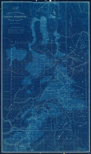
Mining For Gold East of Seattle in the Leavenworth District / Okanogan County at the end of the 19th Century
Detailed map of the mining regions east of the Wenatchee River on the Mad River and Chiwahwah River at the height of the region's mining boom.
The towns of Peshastin, Leavenworth and Chiwaukum are shown as is the Seattle & Montana Railway (called here Great Northern RR) and a wagon road west of the Columbia.
The second map shows the claims on the Monterey Gold Mining & Milling Company along the Mad River.
Monterey Gold Mining and Milling Company
The following is excepted from Hodges, Mining in the Pacific Northwest (1897).
On the summit of the range between Mad River and the Chiwah is another section of the [Leveanworth] district, of granite and shale formation, which is reached from Leavenworth by fourteen miles of road and three miles of trail. On this range are two great parallel ledges of light green schistose talc between granite walls, carrying free gold. The Monterey Gold Mining and Milling Company has nine claims, comprising the Georgie Smith group. Eight claims are on a ledge of light green talcose quartz sixty feet wide, with no defined pay streaks, which was tapped in thirty-five feet by a cross-cut last summer. The gold is said to be all free and assays of surface specimens have run $3.25, $125, $350 and $3,128 gold. The other claim is on a seven-foot cross ledge. The company is about to erect a ten-stamp mill and will begin milling ore this spring
Blueprint maps
Blueprint maps were among the most popular means for the swift printing of maps for which there would be a limited demand. A blueprint map could be made and/or revised much more quickly than a lithograph, cerograph, or other printing method, and at a much lower cost.
Blueprinting as a method was invented in 1842 by John Herschel, a chemist, astronomer, and photographer. A cyanotype process, one starts by drawing on semi-transparent paper, weighted down by a top sheet of paper. The paper would be coated with a photosensitive chemical mixture of potassium ferricyanogen and ferric ammonium citrate. The paper would then be exposed to light, wherein the exposed portions turned blue and the drawn lines, protected from exposure, would remain white.
The blueprint process was an improvement on the expensive and time-consuming method of hand-tracing original documents. The technique was particularly popular with architects; by the 1890s, a blueprint was one-tenth the cost of a hand-traced reproduction. It could also be copied more quickly.
Blueprint maps began to appear as early as the 1850s and 1860s, but they really began to become the standard for mining and similar limited-purpose maps by the 1880s. The ability to create these maps quickly and at a low cost made them the standard for short-run prints, ideal for mapping mining regions in the West and for similar purposes.
The method still exists today, but in a very limited fashion. In the 1940s, diazo prints (whiteprints or bluelines) became more popular, as they were easier to read and faster to make. The blue lines on a white background of these prints are now what most people call blueprints.
Rarity
The map is apparently a unique survival. We were unable to locate any other examples of the map.
![[ Pacific Northwest - Northwest Passage ] Limes Occidentis Quivira et Anian. 1597](https://storage.googleapis.com/raremaps/img/small/71207.jpg)

![[Alaska to San Diego and San Qunitin, British Columbia] A Chart Shewing Part of the Coast of N.W. America, with the Tracks of His Majesty's Sloop Discovery and Armed Tender Chatham . . . (First Modern Map of the West Coast of North America)](https://storage.googleapis.com/raremaps/img/small/102067.jpg)