|
||

|

|
|

|
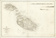
Rare antique engraved chart of St. Paul's Bay, Malta, published by William Heather in London.
The chart is oriented with south at the top. It includes soundings, some topographical features and anchorages.
Salmonetta is St. Paul's Island. A number of lighthouses and towers are shown, along with "Redemption", a tower which we cannot identify, but appears to be in the area of Għajn Ħadid Tower.
The charts from Heather's New Mediterranean Pilot . . . are extremely rare on the market. This is the first example of the chart we have ever seen.
Heather's The New Mediterranean Pilot
This small chart comes from the first English attempt at a collection of ports of the Mediterranean, although the genre was well established in France, Italy, and Spain already. The first was published by Joseph Roux in Marseilles in 1764, with versions published in several Italian port cities.
The French and Italian versions were of relatively crude execution, but Heather’s version is notable for the finely engraved charts, many signed in monogram by the London engraver John Stephenson.
![Valetta, the Capital of the Island of Malta [with] Balearic Islands [and] Corsica and Sardinia](https://storage.googleapis.com/raremaps/img/small/87300.jpg)
![Valetta, the Capital of the Island of Malta [with] Balearic Islands [and] Corsica and Sardinia](https://storage.googleapis.com/raremaps/img/small/60552.jpg)