|
||

|

|
|

|
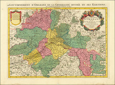
A Major European Port for the 18th Century Slave Trade
A fine detailed large scale map of Nantes, at the height of the French slave trade.
This impressive city plan is a reduced size version of the 4 sheet map produced by François Cacault, who was primarily known as a road engineer, and laid the framework for the late 18th century beautification of the city. First published in 1759, Cacault's map is the finest map of Nantes from the time when it controlled -- and was substantially enriched by -- the French slave trade. The map shows a city that was evolving beyond its important role as a regional port and entrance to the Loire Valley into a central participant in the Triangular Trade.
The highly decorative map contains a title cartouche at the upper right, a dedication cartouche at the upper left.
Le Rouge has added additional embellishments to the map, including the coats of arms of Belabre, Premion, Colet, Periselle, Portie and Grout d'Hollande, along with a list of 57 named streets.
To the west of the city is shown the construction docks where ten vessels are shown in production. There are several monasteries and convents, some of the Capuchin Order. The Château des ducs de Bretagne occupies the bank of the Loire just to the east of the city. The map is interesting in its focus on the alluvial plain, which occupies a large portion of the image.
The map stretches from Hameau de Pirmil in the south, to the Capuchin hermitage in the west, just north of the Place Viarme, and to the east of the suburbs of St. Clement and Richebourg.
The Slave Trade in Nantes
Nantes had long been an important French port city; situated just up the Loire River from the Bay of Biscay, and it occupied an ideal position of access to the interior of France. In 1685, with the passage of the Code Noir and the legalization of the slave trade, the city's traders began building and financing expeditions to the West African coast.
In the mid-18th century the city controlled around 50% of the slave trade in France. Almost all of the slaves owned and shipped by Nantes firms ended up in French Antilles colonies. French slave ships frequently sold their human cargo in Haiti, where plantation owners were often from Nantes.
In the 18th century, over 1400 voyages left Nantes to buy African captives. In its entire one hundred and fifty year history in the slave trade, Nantes slave traders were responsible for transporting more than 500,000 men and women to the Americas.
The slave trade generated profits which were spent on stately homes, civic projects, and the like, but it also gave rise to flourishing related industries, namely those that produced goods for which slaves could be purchased in Africa. Textiles were commonly traded for slaves and so by 1780 Nantes had more than 10 textile mills, employing some 4,500 workers.
In the 1750s before the completion of this plan, ships from Nantes were setting the standard in the Triangular Trade; the Saint-Phillipe, which was owned by the Jogue brothers, made the middle passage crossing with 462 slaves in 25 days. Even after the slave trade was officially ended in 1818, the trade out of Nantes continued; in the decade following, there were 305 voyages to the African coasts from the Nantes docks.
Rarity
The map is extremely rare. OCLC locates only a facsimile of the map in the Bibliotheque National de France.
![[Duchy of Anjou] Exacta novaque descriptio ducatus Andegavensis: quem vulgari nomine le duche d'Aniou indigitant](https://storage.googleapis.com/raremaps/img/small/75391.jpg)