This item has been sold, but you can enter your email address to be notified if another example becomes available.


|
||

|

|
|

|
Stock# 71574
Description
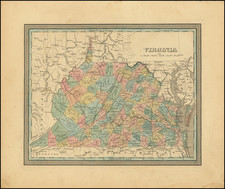
Detailed map of Virginia, from Tanner's Universal Atlas.
Detailed and interesting map, hand colored by county and showing towns, rivers, bays, lakes, railroads, roads, distances, etc. Tables of Steam Boat routes and distances. Population Table by County and by decade.
Condition Description
Minor foxing.
![Virginia [with] Western Portion of Virginia](https://storage.googleapis.com/raremaps/img/small/86438.jpg)
![[Battle of Yorktown] Plan D'York en Virginie avec les attaques et les Campemens de l'Armee combinee de France et d'Amerique](https://storage.googleapis.com/raremaps/img/small/102603.jpg)