


|
||

|

|
|

|
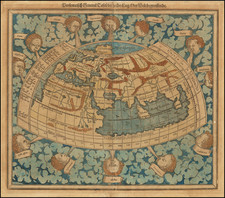
Nice example of Munster's second ancient map of the World, based upon the writings of Ptolemy.
This extraordinary representation of the ancient world map as drawn by Claudius Ptolemy, issued by Sebastian Munster in his renowned Cosmographia beginning around 1578, is a treasure trove of early cartographic design, pre-Columbian lore, and Ptolemaic cosmography.
The map is enclosed in an intricately designed border, featuring twelve windheads symbolizing the winds from classical geography, each with their unique expressions, capturing the constant and various forces that the ancients believed influenced the world's climates. These windheads are elegantly interspersed among billowing clouds, illustrating the heavens' purported role in earthly events.
The depiction of Africa reflects Ptolemy's and Munster's shared vision, which was, in essence, limited by the geographical knowledge of their time. The continent, vast yet unexplored, is delineated by sketchy outlines and largely oversimplified topography. The Nile, a significant feature of Africa, is depicted based on Ptolemy's understanding. The river is shown with its sources springing from the lakes in the mountains south of the equator, reflecting the blend of empirical knowledge and speculation of the time.
Interestingly, the Indian Ocean is depicted as a closed sea, typical of the Ptolemaic conception. This reflects the understanding of the world before Vasco da Gama circumnavigated the Cape of Good Hope and proved otherwise.
The depiction of Taprobana and India is significant in this map. Taprobana (thought by some to represent Sri Lanka, by others a phantom island, or even Sumatra) is given considerable attention and appears oversized, reflecting Ptolemy's fascination with this mysterious island. India, on the other hand, is shown with a somewhat distorted coastline, showcasing the limitations in geographical understanding of the time.
Munster's map reflects a complex blend of classical and medieval geographical knowledge. As a relic of a bygone age, it offers us insight into the worldview of some of the greatest minds of the time, as well as the prevailing beliefs and misconceptions that would only be corrected by explorers in the centuries to follow.
Sebastian Münster (1488-1552) was a cosmographer and professor of Hebrew who taught at Tübingen, Heidelberg, and Basel. He settled in the latter in 1529 and died there, of plague, in 1552. Münster made himself the center of a large network of scholars from whom he obtained geographic descriptions, maps, and directions.
As a young man, Münster joined the Franciscan order, in which he became a priest. He then studied geography at Tübingen, graduating in 1518. He moved to Basel, where he published a Hebrew grammar, one of the first books in Hebrew published in Germany. In 1521 Münster moved again, to Heidelberg, where he continued to publish Hebrew texts and the first German-produced books in Aramaic. After converting to Protestantism in 1529, he took over the chair of Hebrew at Basel, where he published his main Hebrew work, a two-volume Old Testament with a Latin translation.
Münster published his first known map, a map of Germany, in 1525. Three years later, he released a treatise on sundials. In 1540, he published Geographia universalis vetus et nova, an updated edition of Ptolemy’s Geographia. In addition to the Ptolemaic maps, Münster added 21 modern maps. One of Münster’s innovations was to include one map for each continent, a concept that would influence Ortelius and other early atlas makers. The Geographia was reprinted in 1542, 1545, and 1552.
He is best known for his Cosmographia universalis, first published in 1544 and released in at least 35 editions by 1628. It was the first German-language description of the world and contained 471 woodcuts and 26 maps over six volumes. Many of the maps were taken from the Geographia and modified over time. The Cosmographia was widely used in the sixteenth and seventeenth centuries. The text, woodcuts, and maps all influenced geographical thought for generations.
![(World) Tabu. Nova Orbis [New Map of the World]](https://storage.googleapis.com/raremaps/img/small/102996.jpg)
![[ World ] Nova Totius Terrarum Orbis Geographica Ac Hydrographica Tabula Auct. Henr: Hondio. . . . 1641](https://storage.googleapis.com/raremaps/img/small/85386.jpg)