
This item has been sold, but you can enter your email address to be notified if another example becomes available.


|
||

|

|
|

|
Stock# 71558
Description
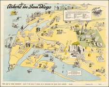
The First Atlas Map of Coronado, California
The map provides a fine town plan of Coronado, with the Library and Park at the center, the pier for the San Diego & Coronado Ferry at the top, and the Coronado Hotel Fair Grounds at the bottom right.
At this time Coronado was accessible via the San Diego & Coronado Ferry (whose dock is visible at the top of the map) and via a road to "Tent City" shown at the bottom of the map.
This is from W.E. Alexander's 1912 Plat Book of San Diego County, California published by the Pacific Plat Book Company of Los Angeles and San Francisco.
Rarity
In over 25 years of business in San Diego, this is the first time we have offered the map for sale.
![[Eastern San Diego County] Cuyamaca Quadrangle](https://storage.googleapis.com/raremaps/img/small/83422.jpg)
![[ Before The Salton Sea ] [ Official Map of San Diego County compiled from latest official maps of U.S. surveys, railroad and irrigation surveys, county records, and other reliable sources . . . Northeast Sheet ]](https://storage.googleapis.com/raremaps/img/small/101378.jpg)
![Camp Pendleton [cover:] Two Weeks With The Marines in California](https://storage.googleapis.com/raremaps/img/small/92525.jpg)