


|
||

|

|
|

|
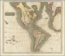
Striking map of America, published by John Thomson in Edinburgh.
Of note, the map incorporates important information from Aaron Arrowsmith's monumental 1804 map of North America, the same map which Lewis & Clark carried with them on their expedition to the Pacific Ocean. Perhaps the most interesting feature is the depiction of the headwaters of the Missouri River. Here, the map incorporates the reports of Peter Fidler for the Hudson's Bay Company, by including a series of possible river courses to the west, leading to (and prospectively through) the Rocky Mountains. It was this section of the map that provided the best depiction of the prospect of a water route or portage through the Rocky Mountains and to the Pacific. It was this information derived from Peter Fidler and incorporated by Arrowsmith, along with reports from local Indians encountered on the expedition, which Lewis & Clark relied in choosing their path to the Rocky Mountains.
The west is New Albion, with only a hint of the Columbia River and no other known rivers. The Upper California Missions are named.
John Thomson (1777-ca. 1840) was a commercial map publisher active in Edinburgh. He specialized in guide books and atlases and is primarily known for his Atlas of Scotland (1832) and the New General Atlas, first published in 1817 and reissued for the next quarter century. The New General Atlas was a commercial success—it was also published in Dublin and London—and it compiled existing geographic knowledge in compelling ways for a wide audience.
His Atlas of Scotland introduced new geographic information and was the first large-scale atlas of Scotland to be organized by county. It provided the most-accurate view of Scotland available before the Clearances. Work on the atlas began in 1820 and led to Thomson’s bankruptcy in 1830 due to the high costs of gathering the latest surveys and reviewing the required materials. Despite the publication of the atlas, Thomson declared bankruptcy again in 1835.
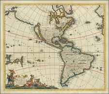
![America noviter delineata Auct. Judoco Hondio [Extremely rare 3 panel carte a figures state]](https://storage.googleapis.com/raremaps/img/small/66116.jpg)
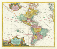
![[Cook's Voyages Printed on Linen] Western Hemisphere or The New World](https://storage.googleapis.com/raremaps/img/small/65080.jpg)