


|
||

|

|
|

|
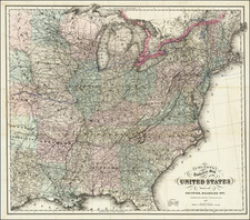
Tennessee Above Kentucky!
Fascinating and very scarce map of the United States, the Caribbean and Central California, published in Vienna.
The map shows the US immediately after the Louisiana Purchase, which is very clearly delineated as Lousiana [sic].
A large region in the Midwest is labeled Teenessee and Kentucket, although the region extends considerably west of to reach the Mississippi River. While Kentucky is corrctly bounded by th Ohio River to the north, Tennessee goes through Indiana and southern Illinois.
The map includs a large unnamed Mississippi Territory, shown just after its creation. The Grosse Meadows Nation is shown on the Missouri River, not far from Alt Ft. St. Louise. Fort Natchitoches is clearly named, as is Presidio dello Adiais. Nice detail along the Rio Grande. Many Indian Tribes shown in the west.
A fascinating look at the Mississippi Valley and contiguous regions shortly after the Louisiana Purchase.
Rarity
This is the second time we have offered the map in 25 years.


![[German Northern Pacific Promotional Tract] Die Nordliche Pacific Eisenbahn; Ihre Route, hulfsquellen, fortschritte & Gefchafte. der neue Nord-Westen und seine grosse Verkehrs-Strasse.](https://storage.googleapis.com/raremaps/img/small/83777.jpg)