|
||

|

|
|

|
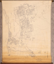
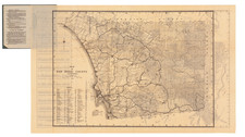
The Earliest Obtainable Map of La Jolla.
Very rare plat map of La Jolla, California from 1912.
The map shows numerous street configurations that never made it into the actual built layout of the Village.
The "La Jolla Rail Road" is shown extending down Electic Avenue and "Covier" Street to Prospect.
Plots are shown, many of which (such as the one on which our shop is located) still exist today.
A number of antiquated neighborhood names are labeled on the map: "La Jolla Park", "La Jolla Beach", "South La Jolla", and "Prospect Park".
A small subdivision off Soledad Avenue called La Jolla Hills is shown as an inset.
This is from W.E. Alexander's 1912 Plat Book of San Diego County, California published by the Pacific Plat Book Company of Los Angeles and San Francisco.
Rarity
In over 25 years of business in San Diego, this is the first time we have offered the map for sale.
OCLC lists no pre-1915 maps of La Jolla, excluding the La Jolla Quadrangle map of the U.S.C.&G.S., and the unobtainable 1885 La Jolla Park, San Diego Co. California map by M.G. Wheeler.
![[ West Mission Valley / University of San Diego / Midway / Sports Arena ] Map Showing the subdivisions in the partition suit of Steele vs. Steele, No. 5620 in the Superior Court. County of San Diego. And the allotment as made by the Referees, Surveyed by O. N. Sanford C.E. . . . Nov 1891.
Nov. 1891](https://storage.googleapis.com/raremaps/img/small/96483.jpg)