


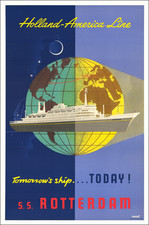
|
||

|

|
|

|
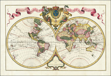
Planiglobii Terrestris Cum Utroq Hemisphaerio Caelesti Generalis Exhibitio by Johann Baptist Homann, printed in Nuremberg in 1720, exemplifies the cartographic practices and aesthetic sensibilities of the early 18th century. This double hemisphere map of the world is notable not only for its geographical representation, showcasing the familiar inaccuracies of the period such as an incomplete Australia, but also for its lavish artistic embellishments. These include celestial depictions for both the northern and southern hemispheres, allegorical representations merging science and fantasy, and detailed portrayals of natural phenomena, including the activity of volcanic mountains and the enigmatic whirlpools.
During the early 18th century, cartography was transitioning from being solely a tool for navigation to a medium for conveying a broader understanding of the world, both geographically and scientifically. The map's inclusion of cartographic inaccuracies speaks to the limited knowledge of certain regions during this time. The treatment of areas like Southeast Asia, Japan, and the Northwest Coast of America sheds light on the cartographic techniques and sources that informed this work.
The allegorical scenes framing the map blend empirical observation with speculative science and myth. Notably, the celestial hemispheres present a view of the skies that would have been understood in Homann’s time, combining astronomical data with artistic rendition. One particularly evocative depiction is that of the "Maelstrom" near Norway—a marine whirlpool known for its powerful currents and the peril it posed to seafarers. The descriptive text below the map, addressing the "Benevole Spectator," serves as both an artistic embellishment and an informative commentary on the natural phenomena illustrated, ranging from the behavior of volcanic mountains to the formation of rainbows.
The Map's Text
In the accompanying text, the creators have put forth an extensive exposition that seeks to illuminate various natural phenomena depicted on the map. The passage sheds light on several subjects: the mysteries of volcanoes, some of which have been burning since the world's inception, while others have recently sprung to life; the perplexing causes behind earthquakes, and the challenges faced by scholars in understanding the ebb and flow of tides, especially its relationship with the moon's movements. The text further delves into the phenomenon of "Maelstrom" or whirlpools, highlighting the most famed one near Norway, which draws in and expels everything in its vicinity with immense force. Winds are discussed in their role as significant movers of air, influenced by the Earth's rotation and other factors, leading to various climatic events. The text culminates in a discussion on meteorological conditions and phenomena like rain, snow, hail, and the captivating appearance of rainbows. The sign-off wishes the reader well, emphasizing the map's role in elucidating the depicted phenomena.
State
The map can be readily differentiated between early state(s) with California shown as an island, and later ones where this is no longer the case. We have traditionally dated the first state circa 1715 and the later state circa 1720.
If you are aware of further differentiations between the states, or a work that elucidates this, we would be happy to know about it.
Johann Baptist Homann (1663-1724) was a mapmaker who founded the famous Homann Heirs publishing company. He lived his entire life in Bavaria, particularly in Nuremberg. Initially, Johann trained to become a priest before converting to Protestantism and working as a notary.
In 1702, Johann founded a publishing house that specialized in engravings. The firm flourished, becoming the leading map publisher in Germany and an important entity in the European map market. In 1715, Johann was named Imperial Geographer to the Holy Roman Empire by Charles VI and made a member of the Prussian Academy of Sciences. Most importantly for his business, his reputation and contacts gained him imperial printing privileges which protected his publications and recommended him to customers. Johann is best known for this Grosser Atlas ueber die ganze Welt, or the Grand Atlas of the World, published in 1716.
After Johann died in 1724, the business passed to his son, Christoph (1703-1730). Upon Christoph’s early death, the company passed to subsequent heirs, with the name of the company changing to Homann Erben, or Homann Heirs. The firm continued in business until 1848.
![[ World Map ] Карта Шара Земнаго Сочиненная по Астрономическимъ Наблюденїямъ. Жанверомъ. [Globular Map of the Earth Compiled from Astronomical Observations. Janvier]](https://storage.googleapis.com/raremaps/img/small/65900.jpg)