|
||

|

|
|

|
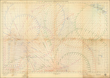
Rare sea chart covering three of the largest Northwestern Hawaiian Islands.
French Frigate Shoals is the largest atoll in the Northwestern Hawaiian Islands. Its name commemorates French explorer Jean-François de La Pérouse, who nearly lost two frigates when attempting to navigate the shoals. La Pérouse, aboard the frigate Boussole, was sailing westward from Monterey en route to Macau. On November 6, 1786, sailors sighted breakers directly in their path, about a thousand feet ahead. Both the Boussole and her companion vessel, the frigate Astrolabe, were immediately brought about, passing within a few hundred feet of the breakers. At daybreak, the ships returned and mapped the southeastern half of the atoll, as well as finding the rock that would later be named after La Pérouse. La Pérouse named the shoals Basse des Frégates Françaises, the "Shoal of the French Frigates".
Laysan Island (Kauō) is a part of the Hawaiian Islands. It is located about 800 miles northwest of Honolulu. The first reported sightings of the island were by Massachusetts whalers in the 1820s. The Nantucket Enquirer reported a sighting in 1825. They were among many who took advantage of the newly discovered whaling grounds off the coast of Japan, making the waters around the Northwest Hawaiian archipelago an increasingly popular commercial route. Various publications name Capt. Stanyukovich of the Russian ship Moller as the discoverer of Laysan. Although he mapped the island in 1828 and attempted to name it for his ship, he clearly was there after the New Englanders, at least. In 1857, Capt. John Paty of the Manuokawai annexed Laysan to the Kingdom of Hawaiʻi.
Lisianski Island is a part of the Hawaiian Islands. It is located about 150 miles southeast of Midway and about 1000 miles west of Honolulu.
The British Admiralty has produced nautical charts since 1795 under the auspices of the United Kingdom Hydrographic Office (HO). Its main task was to provide the Royal Navy with navigational products and service, but since 1821 it has also sold charts to the public.
In 1795, King George III appointed Alexander Dalrymple, a pedantic geographer, to consolidate, catalogue, and improve the Royal Navy’s charts. He produced the first chart as the Hydrographer to the Admiralty in 1802. Dalrymple, known for his sticky personality, served until his death in 1808, when he was succeeded by Captain Thomas Hurd. The HO has been run by naval officers ever since.
Hurd professionalized the office and increased its efficiency. He was succeeded by the Arctic explorer Captain William Parry in 1823. By 1825, the HO was offering over seven hundred charts and views for sale. Under Parry, the HO also began to participate in exploratory expeditions. The first was a joint French-Spanish-British trip to the South Atlantic, a voyage organized in part by the Royal Society of London.
In 1829, Rear-Admiral Sir Francis Beaufort was appointed Hydrographer Royal. Under his management, the HO introduced the wind force scale named for him, as well as began issuing official tide tables (1833). It was under Beaufort that HMS Beagle completed several surveying missions, including its most famous voyage commanded by Captain FitzRoy with Charles Darwin onboard. When Beaufort retired in 1855, the HO had nearly two thousand charts in its catalog.
Later in the nineteenth century, the HO supported the Challenger expedition, which is credited with helping to found the discipline of oceanography. The HO participated in the International Meridian Conference which decided on the Greenwich Meridian as the Prime Meridian. Regulation and standardization of oceanic and navigational measures continued into the twentieth century, with the HO participating at the first International Hydrographic Organization meeting in 1921.
During World War II, the HO chart making facility moved to Taunton, the first purpose-built building it ever inhabited. In 1953, the first purpose-built survey ship went to sea, the HMS Vidal. Today, there is an entire class of survey vessels that make up the Royal Navy’s Hydrographic Squadron. The HO began to computerize their charts in the late 1960s and early 1970s. In 1968, the compilation staff also came to Taunton, and the HO continues to work from there today.
![Oahu [Hawaiian Islands 1:25,000]](https://storage.googleapis.com/raremaps/img/small/96167.jpg)
![[Hawaii / Western Pacific]](https://storage.googleapis.com/raremaps/img/small/73805.jpg)