|
||

|

|
|

|
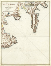
Rare antique engraved chart of Valleta, published by William Heather in London.
The chart is oriented with southwest at the top. It includes soundings, some topographical features and anchorages.
The fortifications of Valletta are shown, along with Fort Ricasoli, Ft. St. Margaret, Citta Singlea, Victgoriosa, Point Dragut, Fort Manuel, Castly St. Angelo and the Palace.
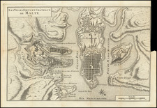
Rarity
The charts from Heather's New Mediterranean Pilot . . . are extremely rare on the market. This is the first example of the chart we have ever seen.
Heather's The New Mediterranean Pilot
This small chart comes from the first English attempt at a collection of ports of the Mediterranean, although the genre was well established in France, Italy, and Spain already. The first was published by Joseph Roux in Marseilles in 1764, with versions published in several Italian port cities.
The French and Italian versions were of relatively crude execution, but Heather’s version is notable for the finely engraved charts, many signed in monogram by the London engraver John Stephenson.
![Malte [Malta | Valetta]](https://storage.googleapis.com/raremaps/img/small/79497.jpg)
![Barbary and Bildulgerid. [on sheet with:] Egypt and Barca &c.](https://storage.googleapis.com/raremaps/img/small/70916.jpg)