


|
||

|

|
|

|
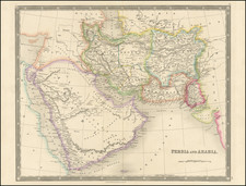
Detailed engraved map of Arabia, Persia and neighboring regions issued by Henry Teesdale in London in 1834.
The map stretches from the Red Sea to Beloochistan and Afghanistan and is centered on the Gulf.
The map includes excellent detail in the Arabian Peninsula, with dozens of towns along the Red Sea. In the Desert regions, a number of interesting place names which existed primarily in the 19th century are shown, along with places marked simple "well" are shown. Further east, on the Gulf, El Katif, Bahharein Island, and Taroot are named north of the Peral Bank, with a few early place names in the area of the modern Dubai and Abu Dhabi.
Persia is divided into regions, including:
- Azerbijan
- Chilan Mazanderan
- Iraka Adjemi
- Fars
- Kerman
- Laristan
- Khorasan
- Cabul
- Balkh
- Afghanistan
- Sinde
Teesdale was a London-based map publisher. He was an early Fellow of the Royal Geographical Society, elected in 1830. Teesdale partnered with John Hordan and William Colling Hodson, but this arrangement dissolved in 1832. Afterward, he continued to work on his own and periodically with colleagues like John Crane Dower, Christopher Greenwood, Josiah Henshall and others. He published a variety of atlases and separately-issued maps. His business was quite successful, as he registered as a partner in the Royal Bank of Scotland in 1845.


![[Ottoman map of the Arabian Peninsula]](https://storage.googleapis.com/raremaps/img/small/99778.jpg)