|
||

|

|
|

|
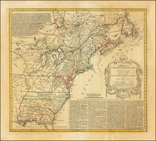
English Edition of the First Geological Map of the United States
Scarce map of the United States., from Volney's A View of the Soil and Climate of the United States.
This is English edition of the first Geological Map of the United States. Curiously, Volney did not use Werner's classification but showed the calcareous, sandstone, and granite. (labeling these with bands running parallel to the Allegheny Mountains on the east coast.
The map extends west to the Missouri River, with the area west of the Mississippi labeled as "Upper Louisiana."
In "West Georgia", the map locates some Indian tribes and gives the number of warriors in each, such as Country of the Chactaws (2000 warriors) and Country of the Creeks (5000 warriors).
The land in western Tennessee is described as "very uneven ground", with Nashville and Knoxville being the only 2 cities in the state which are shown.
The map gives a good early account of the Ohio River Valley, with Gallipolis, Washington, Cincinnati, Lexington, Frankfort and Louisville shown in Ohio and Kentucky, and a road shown from Ft. Vincennes to Detroit (with settlements such as Girtys Town, Loromies Store, and Greenville on the route, along with Lexington, Frankfort and Louisville). Southern Illinois is described as "desert savannahs".
Extensive hachure is used in an attempt to illustrate the complex ranges of the Allegheny Mountains.
Constantin Volney
Constantin François de Chasseboeuf, comte de Volney (1757 - 1820), was a French philosopher, abolitionist, historian, orientalist, and politician. In 1795 he undertook a journey to the United States, where he was accused by John Adams' administration of being a French spy sent to prepare for the reoccupation of Louisiana by France and then to the West Indies. Consequently, he returned to France. The results of his travels were published in his Tableau du climat et du sol des États-Unis (1803).
![[HAPAG Map of the United States and Canada]](https://storage.googleapis.com/raremaps/img/small/78779.jpg)