|
||

|

|
|

|
Stock# 71437
Description
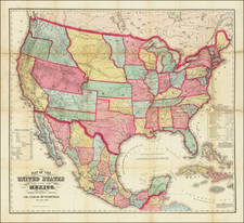
Impressive large-scale antique folding map of the United States, issued by preeminent British map publishers W. & A.K. Johnston in 1894.
The map all of the United States (less Alaska and Hawaii, which were not yet states), and includes detailed inset plans of San Francisco, Chicago, New York, Philadelphia, Boston, and Washington D.C.
The map depicts a split Oklahoma-Indian Territory configuration, which would persist until 1907 when Oklahoma became a state.
The map gives a very detailed treatment of the rail lines that crisscrossed the nation at the end of the 19th century.
Hydrographic features are depicted and labeled in light blue or grey.
Condition Description
Folding map dissected in 50 sections and mounted on original linen. With the original red-cloth case, gilt-lettered "United States".

![[ United States ] Carte Speciale, Historique et. Geographique De La Republique Des Etats-Unis De L'Amerique Du Nord](https://storage.googleapis.com/raremaps/img/small/98460.jpg)