


|
||

|

|
|

|
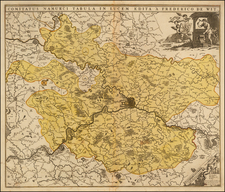
Nice example of this early miniature map of Gallia Belgica, published in Amsterdam by Bertius.
Gallia Belgica ("Belgic Gaul") was a province of the Roman Empire located in the north-eastern part of Roman Gaul, in what is today primarily northern France, Belgium, and Luxembourg, along with parts of the Netherlands and Germany.
In 50 BC, after the conquest by Julius Caesar during his Gallic Wars, it became one of the three newly conquered provinces of Gaul (known as the Tres Galliae (the 3 Gauls), the other two being Gallia Aquitania and Gallia Lugdunensis). An official Roman province was later created by emperor Augustus in 22 BC. The province was named for the Belgae, as the largest tribal confederation in the area, but also included the territories of the Treveri, Mediomatrici, Leuci, Sequani, Helvetii and others. The southern border of Belgica, formed by the Marne and Seine rivers, was reported by Caesar as the original cultural boundary between the Belgae and the Celtic Gauls, whom he distinguished from one another.
The province was re-organized several times, first increased and later decreased in size. Diocletian brought the northeastern Civitas Tungrorum into Germania Inferior, joining the Rhineland colonies, and the remaining part of Gallia Belgica was divided into Belgica Prima in the eastern area of the Treveri, Mediomatrici and Leuci, around Luxembourg and the Ardennes, and Belgica Secunda between the English channel and the upper River Meuse.
Petrus Bertius was a Flemish historian, theologian, geographer, and cartographer. Known in Dutch as Peter de Bert, Bertius was born in Beveren. His father was a Protestant preacher and his family fled to London around 1568. The young Bertius only returned to the Low Countries in 1577, to attend the University of Leiden. A bright pupil, Bertius worked as a tutor and was named subregent of the Leiden Statencollege in 1593. He ascended to the position of regent in 1606, upon the death of the former regent, who was also Bertius’ father-in-law. However, due to his radical religious views, he eventually lost his teaching position and was forbidden from offering private lessons.
His brothers-in-law were Jodocus Hondius and Pieter van den Keere, who were both prominent cartographers. Bertius began his own cartographic publishing in 1600 when he released a Latin edition of Barent Langenes’ miniature atlas Caert Thresoor (1598). He published another miniature atlas that first appeared in 1616.
By 1618, Bertius was named cosmographer to Louis XIII. He converted to Catholicism and took up a position as professor of rhetoric at the Collège de Boncourt (University of Paris). In 1622, Louis XIII created a chart of mathematics specifically for Bertius and named him his royal historian. He died in Paris in 1629.
![[English Channel] De Cust van Vlaenderen en Engelandt van Oostende tot deur de Hoofden](https://storage.googleapis.com/raremaps/img/small/75243.jpg)
![[ Belgium ]. Les Provinces des Pays-Bas Catholiques ou a Most Exact Map of Flanders or ye Austrian Netherlands &c. . . .](https://storage.googleapis.com/raremaps/img/small/102631.jpg)