|
||

|

|
|

|
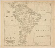
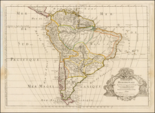
Striking, Detailed Map of South America From the Stielers Handatlas
Comprehensive, large-scale map of South America by August Petermann, one of the foremost cartographers of the nineteenth century.
This map was from the ninth edition of the Stielers Handatlas, the leading German atlas of the late-nineteenth and early-twentieth centuries. Although published in Gotha, this example was sold by Edward Stanford in London, as his plate is added in the lower right of the map. Originally designed by Petermann, it has been updated by H. Habenicht and H. Salzmann, as Petermann died in 1878.
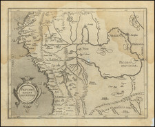
The map features the continent from its connection with Central America, and the Panama Canal, to Tierra del Fuego. The Falklands and a few other small islands are include, such as Fernando-Noronha and Juan Fernandez in the Atlantic and Pacific respectively.
The landmasses are densely covered with toponyms describing all sorts of settlements and geographic features. The Andes, the backbone of the continent, are shown with hachuring. The many rivers are striking, with the mighty Amazon the most prominent.
The many abbreviations are explained in the legend in the top right corner. It explains geographic abbreviations in Spanish, Portuguese, and German. These features include many of the most exciting aspects of South American geography, including volcanoes and waterfalls. They also hint at the continent’s colonial past (and present, at the time this map was made) with forts and mission stations.
In addition to abbreviations, the key also explains the symbols and color-coding present on the map. Pink shading denotes British possessions and can be seen on the Falkland Islands (Malvinas) and British Guyana. Orange shading is a Dutch colony, as with Curacao and Dutch Guyana. Purple is for the French and is seen on French Guyana. An orange dashed line indicates where Germans live. Indigenous peoples are recognized with nations’ names in all caps over their traditional lands or the lands they now inhabit. For cities, a note explains:
The capitals of the individual states, provinces, departments etc. are underlined with the color of the country concerned. The capital letters of the place names and the scripts of the place names indicate the relative importance of the places in general, with special consideration of their population figures.
Dashed lines separate nation states, while dotted lines show their provinces. There are also symbols for forts, ruins, lighthouses, cliffs, passes, railways (in operation and under construction), main streets, canals, swamps, streams, salt marshes, sandbanks, salt lakes, dry salty soil, saltpeter (where one will find nitrate warehouses), and telegraph lines. Dashed lines at sea show the submarine cables that connect South America to other parts of the continent and to the rest of the world.
Tucked into the lower left and right corners are insets of Buenos Aires, Rio de Janeiro, South Brazil, Lima, Santiago, Valparaiso, and the Panama Canal. Each has its own scale and special features. For example, the inset of Santiago locates individual haciendas, while the insets of Buenos Aires and Rio de Janeiro list prominent buildings.
Boundaries and borders of Chile-Bolivia-Peru, Brazil-Peru, and Bolivia-Paraguay
Some of the political boundaries of South America were still in flux in the late-nineteenth century. For example, Bolivia is shown here with no outlet to the sea. Tacna and Tarapaca provinces are part of Chile; they were ceded to Chile from Peru in 1884 after the Peruvian-Bolivian alliance lost to Chile in the War of the Pacific (1879-1884) (Tacna would eventually be returned to Peru). Antofagasta, a nitrate-rich region, is also shown as Chilean; it was occupied by the Chileans as part of the War of the Pacific and was not formally ceded to Chile by Bolivia until 1904.
Another area in flux is the border between Peru and Bolivia. The dashed line is incomplete, showing that some confusion still exists. Additionally, there are two small zones marked “Neutral” near the Purús and Juruá Rivers. The Amazon border between the countries were the subject of three joint boundary commissions in 1866, 1873, and 1877. In 1904, the neutral zones seen on this map were declared, pending further delineation. In 1909 the Velarde-Rio Branco Treaty created the current boundary between the nations.
Another area that differs from the borders of today is the conjunction of Bolivia and Paraguay. Paraguay has a razor-straight border in the northwest. This line was proposed in an 1894 treaty; however, the treaty was never submitted for approval to the Bolivian Congress. In 1913, the states agreed to annul previous agreements and start afresh with direct negotiation, but this did not result in a border. At issue was the Gran Chaco region, thought to be rich in oil. The countries eventually went to war over the area in the Chaco War (1932-5). Paraguay emerged with two-thirds of the disputed territories in the 1938 peace treaty that ceased hostilities.
Stielers Handatlas
This map was part of the Stielers Handatlas, a series of well-respected world atlases. The formal title of the first atlas was the Hand-Atlas über alle Theile der Erde und über das Weltgebäude, which translates as the “Handy Atlas of all Part of the World and the Universe.” Published in German, the atlas appeared in ten additional editions from 1817 to 1945. Each edition was issued in installments and published by Justus Perthes in Gotha, although they were sold around the world.
The first edition appeared as separate plates from 1817 to 1823 and was made by Adolf Stieler and Christian Gottlieb Reichard. This edition aspired to include 50 maps, but only 47 were published. Friedrich von Stülpnagel edited a new edition in 1834-5 with 83 maps. This new edition was the first to be called Stielers Hand-Atlas and is usually referred to as the first edition. The second edition (1846-52) also had 83 maps, while the third edition (1853-1862) has 84. The fourth edition (1863-1867) was the first overseen by August Petermann and had 84 maps. Petermann also edited the fifth edition (1868-1874) with 84 maps.
With the sixth edition (1875-1881), edited by Petermann with Hermann Berghaus and Carl Vogel, the quality and quantity (90) of the map’s increased, gaining them an international reputation and a larger circulation. A seventh edition followed in 1882-1889 with 95 maps. The eighth edition (1890-1902) was edited by Alexander Supan and also had 95 maps.
The earlier editions were printed on copper plate. While some of the maps were later printed using lithography, copper plate was still used, at least in part, until the 1890s. With the ninth edition (1901-5), the now 100 maps were printed on lithographic cylinder machines, making the atlas cheaper and therefore more attainable to a wider reading public. Sixteen of the maps from this edition were translated to English and included in the Encyclopedia Britannica of 1910-1911.
The tenth edition (1920-1945) was considered the centenary edition and included 108 maps, with editorial work by Hermann Haack. Both the ninth and tenth editions were translated into English, and there were editions in French, Italian, and Spanish as well. The final edition (1934-1940) was an international edition of 84 maps, also edited by Haack. There were supposed to be 114 maps, but the Second World War interrupted production. By the ninth edition, the atlases were considered the most comprehensive in the world to that date and were treasured by a wide audience until the mid-twentieth century.
August Heinrich Petermann (1822-1878) is a renowned German cartographer of the nineteenth century. Petermann studied cartography at the Geographical Art-School in Potsdam before traveling to Edinburgh to work with Dr. A. Keith Johnston on an English edition of Berghaus’ Physical Atlas. Two years later he moved to London, where he made maps and advised exploratory expeditions as they set off to explore the interior of Africa and the Arctic.
In 1854, Petermann returned to Germany to be Director of the Geographical Institute of Justus Perthes in Gotha. There, he was the editor of the Geographische Mittheilungen and Stieler’s Handatlas. The Royal Geographical Society of London awarded him their Gold Medal in 1860. He continued his interest in exploration in Germany, fundraising for the German Exploring Expeditions of 1868 and 1869-70, which sought an open Arctic sea. Tragically, he committed suicide in 1878.