


|
||

|

|
|

|
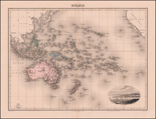
Detailed engraved map of the Pacific issued by Henry Teesdale in London in 1834.
The map covers all of the Pacific from the west coast of the Americas to Australia and New Zealand and East and Southeast Asia.
The Pacific Northwest includes such toponyms as "New Georgia", "New Hanover", "New Cornwall", "New Norfolk", "Russian America", and "Alashka".
Likewise, Australia is filled with some unusual regional toponyms such as "Edels Land", "Lions Land", "Nuyts Land", and "Endrachts Land".
Teesdale was a London-based map publisher. He was an early Fellow of the Royal Geographical Society, elected in 1830. Teesdale partnered with John Hordan and William Colling Hodson, but this arrangement dissolved in 1832. Afterward, he continued to work on his own and periodically with colleagues like John Crane Dower, Christopher Greenwood, Josiah Henshall and others. He published a variety of atlases and separately-issued maps. His business was quite successful, as he registered as a partner in the Royal Bank of Scotland in 1845.
![[Straits of Le Maire, Nova Guinea, South Pacific]](https://storage.googleapis.com/raremaps/img/small/61345op.jpg)
![[South Pacific / Australia to South America] Ins Kleine Gebrachte Karte von dem Mittaeglighen Meere Zur allgemeinen Historie der Reisen](https://storage.googleapis.com/raremaps/img/small/90616.jpg)
![[ The Ptolemaic Universe ] Situs Terrae Circulis Coelestibus Circundatae . . .](https://storage.googleapis.com/raremaps/img/small/101512.jpg)