|
||

|

|
|

|
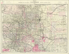
Detailed topographical map showing the region bounded by the Taos, New Mexico area in the southwest, San Luis, Colorado and Trinchera Peak in the northwest, Purgatory River and Trinidad Colorado in the Northeast and the area just south of Laughlin Peak in the southeast.
Shows towns, roads, mountains, rivers, lakes, hydrographical details, etc.
The map was generated during the Wheeler Survey. The Wheeler Survey was a survey of a portion of the United States lying west of the 100th meridian. It comprised multiple expeditions, and was supervised by First Lieutenant (later Captain) George Montague Wheeler. The survey team included Lieutenant (later Brigadier General) Montgomery M. Macomb.
Wheeler led early expeditions from 1869 to 1871 in the west, and in 1872 the US Congress authorized an ambitious plan to map the portion of the United States west of the 100th meridian, at a scale of 8 miles to the inch. This plan necessitated what became known as the Wheeler Survey. The survey's main goal was to make topographic maps of the southwestern United States.
In addition, Wheeler's survey was undertaken to ascertain everything related to the physical features of the region; discover the numbers, habits, and disposition of Indians in the section; select sites for future military installations; determine facilities available for making rail or common roads; and note mineral resources, climate, geology, vegetation, water sources, and agricultural potential.
The Wheeler Survey lasted until 1879, when the survey, along with the King and Powell Surveys, were terminated and their work was reorganized as the United States Geological Survey.