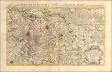
The Catholick Provinces of the Low Countries Distinguished according as they are at present divided between the King of Spain, the King of France, and the States General of the United Provinces . . .
All of our maps are authentic antique maps, printed or drawn on or about the date shown in the description. In rare instances when we offer facsimiles, we will specifically describe the map as a later facsimile and include the date of publication. Certificates of Authenticity are included with each item.
Map Maker
Fast, Global Shipping
Last year we shipped over 4,500 antique maps to more than 50 countries. Maps are shipped Monday through Friday year-round. If an order is received before 2 PM PST, we will ship the order that day. If an order is received after that time, we will ship the next day. We ship maps either flat in custom packages or in specially ordered thick tubes. Shipping rates are provided as part of the checkout process.
Description
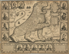
An English Rarity
Nice example of William Berry's map of Belgium, published in London.
The map is drawn from Adrien Hubert Jaillot's map of 1674, which has been "corrected and amended" by Berry.
Condition Description
2-sheets, joined. Minor discoloration at centerfold.


![[Course of the Rhine River] Nova Tractus Totius Rheni Oder Neue beschreibung des Rhein-Strom](https://storage.googleapis.com/raremaps/img/small/58670.jpg)