
The item illustrated and described below is sold, but we
have another example in stock. To view the example which
is currently being offered for sale, click the
"View Details" button below.


|
||

|

|
|

|
Stock# 71309
Description
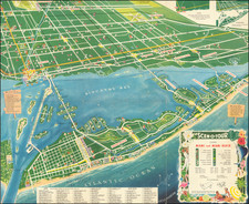
Beautiful vintage bird's eye view of Miami Beach and Miami beyond, published by the Scenotour Publishing Company in 1955.
The map features Miami Beach in the foreground with large hotels and other landmarks (six synagogues!) illustrated pictorially. It extends north to Bal Harbour and Opa-Locka and west to Miami International Airport. Additionally, the map covers parts or all of Miami Springs, Hialeah, El Portal, Miami Shores, North Bay Village, Indian Creek Village, Surfside, Bay Harbor, North Miami, Biscayne Park, and Miami Shores.
45 points of interest are enumerated in the key at the bottom of the map.
This is one of the best decorative maps of Miami from the mid-20th century.
Condition Description
Folding map.
Reference
See Touchton Map Library 2017.064.019.
![[Pensacola] Piano del Porto, e degli Stabilimenti di Pensacola](https://storage.googleapis.com/raremaps/img/small/89465.jpg)

![Island of Cuba (Spanish) and Jamaica (British) [also South Florida, Bahamas and Cayman Islands]](https://storage.googleapis.com/raremaps/img/small/98323.jpg)
![[ Charleston, Boston, New York, St. Augustine, Bahamas, etc ] Particular Draughts of some of the Principal Towns and Harbours belonging to the English French and Spanish in America and the West Indies.](https://storage.googleapis.com/raremaps/img/small/102804.jpg)