


|
||

|

|
|

|
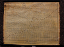
Detailed engraved comparative charts of Mountains & Rivers, issued by Henry Teesdale in London in 1834.
The images of the rivers are interesting arrayed around the mountains, with tables below.
A number of Volcanos are shown, along with images of major cities, showing their relative heights with Riobuma City the highest at 18,800 feet and Quito the highest major city.
At the upper right, a small hot air balloon is shown, labeling the height of 22,900 feet reached by Guy Lusach in 1804.
Teesdale was a London-based map publisher. He was an early Fellow of the Royal Geographical Society, elected in 1830. Teesdale partnered with John Hordan and William Colling Hodson, but this arrangement dissolved in 1832. Afterward, he continued to work on his own and periodically with colleagues like John Crane Dower, Christopher Greenwood, Josiah Henshall and others. He published a variety of atlases and separately-issued maps. His business was quite successful, as he registered as a partner in the Royal Bank of Scotland in 1845.
![(South Sea Bubble) De Windverkopers of Windvangers, die door wind, verliezen Geld en Goed; bederven Vrouw en Kind [The wind sellers or wind catchers, who through wind, lose money and goods; ruin wife and child.]](https://storage.googleapis.com/raremaps/img/small/95952.jpg)
![(Photograph album) America | Hawaii. 1885. [Photographic album of Hawaii, Yellowstone, Utah, Colorado, and Niagara Falls]](https://storage.googleapis.com/raremaps/img/small/87949.jpg)
