|
||

|

|
|

|
The Duke of York's Copy
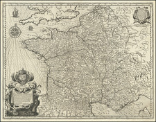
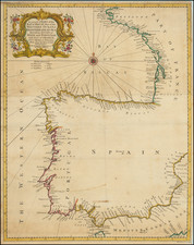
Nice example of Jaillot's map of the region centered on Bar le Duc, in eastern France, with the bookplate of the Duke of York on the verso.
The Duke of York as a Prolific Map Collector
Frederick Augustus, Duke of York and Albany, (1763-1827), was the second son of King George III, and much like his father, a prolific collector of books and maps. A grand library was a necessity for a gentleman of his standing in Georgian Britain, regardless of his occupation, but as a lifelong military man (eventually Commander-in-Chief of the Forces), it was especially important for the Duke of York.
The Duke collected maps, prints, and books throughout his life. In the 1790s, he commissioned the printseller Holland to gather rare 18th-century satirical prints into a series of albums for him. That collection grew to encompass four albums and several hundred prints. His book collection was larger by several orders of magnitude; when it was finally sold after his death in 1827, it took 22 days (starting on May 7, 1827) for Sotheby's to sell the 5548 lots of books from his library. As the Duke of York was not directly in line for the Crown, his collection did not become part of the Royal Collection.
At the end of the 200-page Sotheby's book sale catalog was an advertisement for the sale of the Duke's over-800-lot map collection:
MAGNIFICENT MAPS AND CHARTS.
The most extensive and invaluable Selection of MAPS and CHARTS, the Property of HIS ROYAL HIGHNESS THE DUKE OF YORK, DECEASED.
Including a Grand Classical Arrangement of "Chartae Geographicae"; or a Collection of Maps and Charts in reference to Ancient and Modern Geography, contained in Eighty-Six [actually Eighty-Eight] Atlas Book-Boxes, 2 feet high by 16 inches wide, uniformly bound and lettered with the Contents.
The Duke of York's Chartae Geographicae Map Collection
The map collection was of vital professional interest to the Duke, as well as an obvious focus of his collecting passion. And the crowning jewel of the map collection was the 88-volume boxed set of maps, each bearing the Duke of York's bookplate (with his coat of arms and "DY") as well as the volume number and map number.
In Harley and Walters' article on early English map collecting, they identified the Duke's boxed-map collection as being the most important from the period:
This item, lot No. 238, was in itself a veritable map library of world-wide proportion. It was cited in the catalogue as 'Chartae Geographicae antiquae et recentiores-Collection-in reference to antient and modern geography, consisting of 5,500 maps, engraved by the early modern geographers, contained in 88 folio Double Book Cases, and properly lettered'. It was sold for £400 to Cochran.
Select maps from the Duke of York's collection have appeared on the market in the last few decades, though we have not been able to trace the actual volumes beyond their sale to Cochran (almost certainly the London bookseller John Cochran) in 1827.
Alexis-Hubert Jaillot (ca. 1632-1712) was one of the most important French cartographers of the seventeenth century. Jaillot traveled to Paris with his brother, Simon, in 1657, hoping to take advantage of Louis XIV's call to the artists and scientists of France to settle and work in Paris. Originally a sculptor, he married the daughter of Nicholas Berey, Jeanne Berey, in 1664, and went into partnership with Nicholas Sanson's sons. Beginning in 1669, he re-engraved and often enlarged many of Sanson's maps, filling in the gap left by the destruction of the Blaeu's printing establishment in 1672.
![[ Roman Gaul ] Gallia Antiqua ex Aevi Romani Monumentis Eruta Et Sermi. Carnutum Ducis Munifentia Publici Juris Facta Acutor D'Anville . . . MDCCLX](https://storage.googleapis.com/raremaps/img/small/103405.jpg)