|
||

|

|
|

|
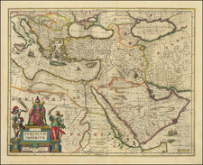
The First Atlas Map of Greece and Turkey Published In the Muslim World
Fine map of part of "the Exalted State" showing modern day Greece, Western Turkey and the south part of Albania, one of 24 maps which appeared in the Cedid Atlas Tercümesi.
Centered on the Aegean Sea, the map extends northeast to the Sea of Marmara and Istanbul, southeast to Rhodes and Fethiye, south to Crete and north to the southern part of Albania and the southern coast of Italy, between Otranto and Santa Maria di Leuca.
The title translation is
This is the map of some of the islands in the Mediterranean, except for Cyprus and the lands in Western Anatolia and Rumelia under the rule of the Exalted State
or in modern Turkish:
Devlet-i aliyye zabtında Anadolu-yı Garb tarafı ve Rumeli'nde biraz mikdar ve Akdeniz'de Kıbrıs'dan maada cümle adaların haritasıdır
Cedid Atlas Tercümesi
The map appeared in the Cedid Atlas Tercümesi, or New Atlas, was published in Istanbul in 1803 by the Ottoman Military Engineering School Press, and is generally considered to be the first atlas to be printed in the Muslim world.
Although manuscripts and hand-drawn maps were widely available throughout the Muslim world, the massive printing of books started only in 1729 by Ibrahim Muteferrika and the Cedid Atlas could only be published in 1803 by Müderris Abdurrahman Efendi in a style based on European sources.
The Cedid Atlas includes a monochrome celestial chart and 24 hand-colored copper engraved maps of various parts of the world. The maps are adapted of William Faden's General Atlas. The maps are preceded by a treatise of geography, "Ucalet-ül Coğrafiye" by Mahmud Raif Efendi. The "Ucalet-ül Coğrafiye" of Mahmud Raif Efendi was printed one year later, in 1804, and bound together with the atlas.
Produced as part of the “New Order” of Sultan Selim III, the atlas was intended to provide military students and officials with modern geographic information. The atlas was part of an effort to incorporate Western military and technological advances into Ottoman society.
Consisting of a treatise on geography, a celestial chart and 24 maps of the world, from Turkey and the Mediterranean to the brand-new United States, the atlas was based on the works of English cartographer William Faden and his General Atlas.
Rarity
Only 50 copies of the atlas were printed, many of which were destroyed in a fire in 1808. It is believed that less than 20 example of the atlas survive today.
This is the first example of the map we have seen on the market.
![Asia Minoris Iacobi Cantelli Vineolensis . . . 1686 [Shows Cyprus]](https://storage.googleapis.com/raremaps/img/small/37656.jpg)
![[Corfu]](https://storage.googleapis.com/raremaps/img/small/40413.jpg)
![Carte de la Grece Dressee sur un grand nombre de memoires anciens et nouveaux, Sur ceux de Mrs. Whele et Tournefort . . . 1745 [includes Cyprus]](https://storage.googleapis.com/raremaps/img/small/94008.jpg)