


|
||

|

|
|

|
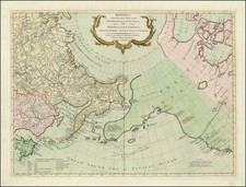
Late 18th Century Scientific Expedition In the North Atlantic
Important mid-18th Century sea chart of the North Atlantic, published by the French Depot de la Marine.
Centered on Iceland, the map extends from Labrador, Newfoundland, and Baffin Island (Ile James) to Norway, and includes Greenland, Great Britain, Denmark, and part of the coast France, inland to Paris. It is a fine chart with fleur-de-lis and rhumb lines and a table of coordinates for major locations at right.
Between 1771 and 1772 the French government sent a scientific expedition to the North Atlantic, led by Verdun de la Crenne, to explore the ocean, the coasts, and the islands on their route and to correct errors on existing charts and test various ways of measuring latitude and longitude.
The expedition reached Iceland in the Western Fiords and remained for nearly three weeks in Patreksfjördur, making numerous observations. Based on these measurements they moved the country three and a half degrees eastwards, though without disturbing the longitude of the east coast to any extent. Restricted to a limited area on about one third of the Icelandic coast, their charting of Iceland was generally much less accurate than those already in existence. The expedition had particular difficulty in fitting in all of the south and north coasts within the narrow limits imposed by their estimate of the breadth of the country from east to west.
The Dépôt de la Marine, known more formally as the Dépôt des cartes et plans de la Marine, was the central charting institution of France. The centralization of hydrography in France began in earnest when Jean-Baptiste Colbert became First Minister of France in 1661. Under his watch, the first Royal School of Hydrography began operating, as did the first survey of France’s coasts (1670-1689). In 1680, Colbert consolidated various collections of charts and memoirs into a single assemblage, forming the core of sources for what would become the Dépôt.
The Dépôt itself began as the central deposit of charts for the French Navy. In 1720, the Navy consolidated its collection with those government materials covering the colonies, creating a single large repository of navigation. By 1737, the Dépôt was creating its own original charts and, from 1750, they participated in scientific expeditions to determine the accurate calculation of longitude.
In 1773, the Dépôt received a monopoly over the composition, production, and distribution of navigational materials, solidifying their place as the main producer of geographic knowledge in France. Dépôt-approved charts were distributed to official warehouses in port cities and sold by authorized merchants. The charts were of the highest quality, as many of France’s premier mapmakers worked at the Dépôt in the eighteenth century, including Philippe Bauche, Jacques-Nicolas Bellin, Rigobert Bonne, Jean Nicolas Buache, and Charles-François Beautemps-Beaupré.
The Dépôt continued to operate until 1886, when it became the Naval Hydrographic Service. In 1971, it changed names again, this time to the Naval and Oceanographic Service (SHOM). Although its name has changed, its purpose is largely the same, to provide high quality cartographic and scientific information to the France’s Navy and merchant marine.
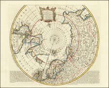
![Hemisphere Septentrional du Globe Terrestre Veu en concave l'oeil estant au Pole AntArctique . . . 1696 [and] Hemisphere Superieur du Globe Terreste pour l'Horizon de Paris Veu en convexe l'oeil etant pose au zenith et a distance infinie du plan de projection . . . 1697](https://storage.googleapis.com/raremaps/img/small/85541.jpg)
![[Angra - Madera - Porto Santo - Sao Miguel] Pascaarte vande Eijlanden van Madera en Port Sancto, vertoonende degelegentheijt vande Reede aldaer en hoese van malcanderen zijn gheleghen . . .](https://storage.googleapis.com/raremaps/img/small/62128.jpg)