


|
||

|

|
|

|
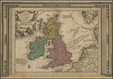
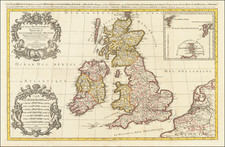
Fine, Detailed Map of the British Isles -- Colored By Heptrachys!
Decorative, large-format map of the British Isles by Jaillot, issued in full original color. The map is colored by Heptrachys, which is a very unusual feature for Jaillot's map.
Portions of France, Belgium, and the Netherlands are included to the east, separated from England by the Pas de Calais. The Western Isles and the Orkneys are off of Scotland, while the Scilly Islands are just west of Cornwall. In the upper right corner is an inset of the Upper Orkneys with the Faroes and Shetlands northwest and northeast respectively.
The British Isles are divided into nations and counties, with towns, cities, and rivers highlighted. Hadrian’s Wall is prominently shown. The wall was built by the Romans in 122 CE to protect their settlements in the south. London and Westminster are marked as close, yet separate cities.
The western portion of the map is filled with decorative elements. In the upper left is an elaborate floral motif flanked by rearing horses. Poseidon is sunning himself in a frame at the base. In the lower left corner is an impressive scale bar characteristic of Jaillot.
Unique Variant
The present example is in exceptional old color.
One very curious feature of the present example is that a basket at the top of the scale bar has been cut out. A more elaborate image of two cherubs has been pasted in instead. As the color matches of the pasted portion matches the rest of the map exactly, this change was apparently made by the publisher or the first owner.
Alexis-Hubert Jaillot (ca. 1632-1712) was one of the most important French cartographers of the seventeenth century. Jaillot traveled to Paris with his brother, Simon, in 1657, hoping to take advantage of Louis XIV's call to the artists and scientists of France to settle and work in Paris. Originally a sculptor, he married the daughter of Nicholas Berey, Jeanne Berey, in 1664, and went into partnership with Nicholas Sanson's sons. Beginning in 1669, he re-engraved and often enlarged many of Sanson's maps, filling in the gap left by the destruction of the Blaeu's printing establishment in 1672.
![[ Genealogy of the English Monarchy ] Reges Angliae Inclijto ac Potentiss](https://storage.googleapis.com/raremaps/img/small/99752.jpg)