


|
||

|

|
|

|
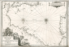
Rare chart of the Strait of Messina, separating Sicily and Calabria in Italy, published by William Heather in London.
The chart is oriented with west at the top. It includes soundings, some topographical features, anchorages, and currents.
The towns of Messina, Regio, Sigla, etc. are labeled with their fortifications shown.
Rarity
The charts from Heather's New Mediterranean Pilot . . . are extremely rare on the market. This is the first example of the chart we have ever seen.
Heather's The New Mediterranean Pilot
This small chart comes from the first English attempt at a collection of ports of the Mediterranean, although the genre was well established in France, Italy, and Spain already. The first was published by Joseph Roux in Marseilles in 1764, with versions published in several Italian port cities.
The French and Italian versions were of relatively crude execution, but Heather’s version is notable for the finely engraved charts, many signed in monogram by the London engraver John Stephenson.
![[ Lazio ] Campagna di Roma, olim Latium: Patrimonio Di S. Pietro; et Sabina](https://storage.googleapis.com/raremaps/img/small/98622.jpg)
![[Pompei] Nuova Pianta Degli Scavi di Pompei](https://storage.googleapis.com/raremaps/img/small/70053.jpg)
![[Spanish Siege of Ostia] Il Vero Disegno Del Sito Di Hostia e Di Porto Con Li Forti Fatti Dal Campo Di Sua Santita et Delli Imperiali Qualisi Resero Adi XXIIII Genaro M. D. L V II . . . .](https://storage.googleapis.com/raremaps/img/small/75401.jpg)
![[Pozzuoli] Explicatio aliquot locorum quae Puteolis spectantur](https://storage.googleapis.com/raremaps/img/small/75348.jpg)