|
||

|

|
|

|
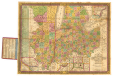
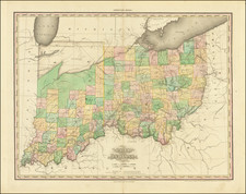
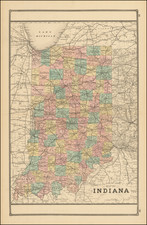
Full color example of the first edition David Burr's map of Indiana, which appeared in his Universal Atlas, first issued in 1836.
Includes fascinating primitive counties, including massive regions designated for the Pottawatomies and Miamis Indians, and massive Elkhart County above it. An Indian Reservation appears in Allen County. Other counties are unnamed or are still Indian Regions. Shows towns, rivers, roads, railroads, Indian settlements, forts, a proposed canal, etc.
Burr's Atlas was perhaps the most elegant American commercially published atlas of its time, utilizing wonderful wash colors and elegant engraving style. Burr studied under Simeon DeWitt in New York. His first atlas was an Atlas of New York State, the second state atlas to be issued in the US (after Mills Atlas of South Carolina in 1826). In the 1830s, he served as topographer for the US Post Office, producing a series of rare and highly sought after large format state maps during this period. Later, he was appointed as the Geographer of the House of Representatives, where he served during the later part of the 1830s.
Burr is widely regarded as one of the most important names in American Cartographic history.
David H. Burr studied law, passing the New York Bar Exam, and then surveying under Simeon DeWitt in New York. His first atlas was an atlas of New York State (1829), the second state atlas to be issued in the US (after Mills’ Atlas of South Carolina in 1826). In the 1830s, he served as the official topographer for the US Post Office, producing a series of rare and highly sought-after large-format state maps. He also created a map of the country’s postal routes, which features roads, canals, and railroads. Burr traveled to London to work with John Arrowsmith; together, they produced the American Atlas in 1839.
Upon his return to the States, Burr was appointed as a draftsman for the House of Representatives, where he worked until ca. 1841. He later worked for the Louisiana Survey and the Florida Survey. By 1850, he was back in Washington D. C., working on the census. In 1852, the Senate named Burr as the draftsman to compile maps from the Federal Surveys. In 1853, Burr traveled to San Francisco, perhaps as part of his work for the Senate. He was then named as the Surveyor General of Utah in 1855. However, he was unpopular there and returned to Washington D. C. by 1870. Burr is widely regarded as one of the most important names in the nineteenth-century American history of cartography.