This item has been sold, but you can enter your email address to be notified if another example becomes available.


|
||

|

|
|

|
Stock# 71148
Description
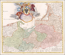
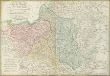
Antique engraved map of the area covering modern-day Poland, the Baltics, and Belarus, by John L. Cowley from “A New and easy introduction to the study of geography”.
The map includes Lithuania as the dominating polity in the region. Along with Volinia, Ukrain or Lower Volinia, Red Russia, Podolia, Samagoria, etc.
![[Holy Roman Empire] A Newe Mape of Germany Newly Augmented by Iohn Speed Ano Dom: 1626](https://storage.googleapis.com/raremaps/img/small/67323.jpg)