


|
||

|

|
|

|
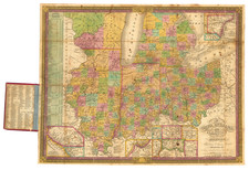
Excellent antique hand-colored engraved map of the eastern Midwest, covering Michigan, Ohio, Indiana, Illinois, and the southern half of Wisconsin.
This is a rare later state of Finley's map of eastern Midwest, first issued in 1825, here in the 1835 Dutton edition. The changes between the 1825 map and this edition are so significant as to bring into question whether they were indeed printed from the same copperplate, but that is the case.
There are four insets, including the great little map "Lead Region East of the Mississippi River", which covers the southwestern corner of present-day Wisconsin, which had just seen the Black Hawk War in 1832. The other insets are "Falls of Ohio", "Vicinity of Cincinnati", and "Vicinity of Detroit". Steamboat routes are listed along the left side of the map.
S. Dutton is probably more commonly associated with the partnership Hinman & Dutton than as a lone publisher. With this map, the partnership was apparently Mitchell & Hinman, with Dutton the publisher. J.H. Young was the engraver.
For a map published under similar circumstances with similar subject matter see this excellent map of Wisconsin Territory.
These later editions of the Finley maps are quite rare, this being the first time we have had a separately-issued edition.