


|
||

|

|
|

|
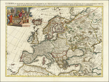
Superb Original Hand-Color Example.
Striking large format map of Europe, by Jaillot, published in Amsterdam circa 1696 by Pierre Mortier.
The map extends as far east as Ural Mountains and west to Iceland. Interestingly, the prime meridian is shown running through Iceland, rather than a European capital as more frequently seen.
First issued in 1674, this two-sheet map of Europe provides a highly detailed picture of the continent, based upon the geographical compilations and work of Nicolas Sanson which remained unpublished at the time of his death.
Not enough can be said about the original hand-coloring of this example, which is especially careful, fresh, and strong.
Alexis-Hubert Jaillot (ca. 1632-1712) was one of the most important French cartographers of the seventeenth century. Jaillot traveled to Paris with his brother, Simon, in 1657, hoping to take advantage of Louis XIV's call to the artists and scientists of France to settle and work in Paris. Originally a sculptor, he married the daughter of Nicholas Berey, Jeanne Berey, in 1664, and went into partnership with Nicholas Sanson's sons. Beginning in 1669, he re-engraved and often enlarged many of Sanson's maps, filling in the gap left by the destruction of the Blaeu's printing establishment in 1672.
Pierre, or Pieter, Mortier (1661-1711) was a Dutch engraver, son of a French refugee. He was born in Leiden. In 1690 he was granted a privilege to publish French maps in Dutch lands. In 1693 he released the first and accompanying volume of the Neptune Francois. The third followed in 1700. His son, Cornelis (1699-1783), would partner with Johannes Covens I, creating one of the most important map publishing companies of the eighteenth century.
![[Untitled Map of The Atlantic Ocean, Europe, Africa, the Middle East, and Eastern Canada]](https://storage.googleapis.com/raremaps/img/small/89582.jpg)

![[ Holy Roman Empire ] Germania, Non ea tantum quae Rheno, Vistula, Danubio, mariqz Germanico Veteribus claudebatur; Sed tota illa continens quae hodie communiter Germanica lingua utitur . . .](https://storage.googleapis.com/raremaps/img/small/99236.jpg)