This item has been sold, but you can enter your email address to be notified if another example becomes available.


|
||

|

|
|

|
Stock# 71131
Description
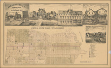
Scarce lithographed map of Montreal, probably from Tackabury's Atlas of the Dominion of Canada (1876).
Hand-colored by wards. Many important public buildings are outlined and labeled. The topography of Mount Royal is rendered with hachuring.
Condition Description
Original hand-color. Stains on both left and right into the image.

![[ St. Lawerence River / Lake Champlain ] Carte Du Cours Du Fleuve De St. Laurent Depuis son Embouchere jusqu'au dessus de Quebec . . .](https://storage.googleapis.com/raremaps/img/small/101652.jpg)