|
||

|

|
|

|
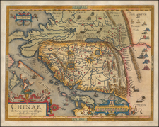
Very Rare English-Language Edition of the Ortelius Map of China.
Fine example of Abraham Ortelius's map of China, from the exceedingly rare English edition of his Theatrum, published only in one year - 1606.
Ortelius' map of China is taken directly from reports of the Portuguese mapmaker Luis Jorge de Barbuda (Ludovicus Georgius), who made a manuscript map of China that reached Ortelius via Arias Montanus. First published in 1584, Ortelius' map of China is the earliest printed map to focus on China and the first to illustrate the Great Wall of China. Tooley referred to the map as the standard map of the interior of China for over sixty years. With its three lushly designed cartouches and many illustrations of indigenous shelters, modes of transportation, and animals, this is one of Ortelius's richest engravings.
When this map appeared, it was by far the most accurate representation of China to appear on a printed map. Japan is shown on a curious curved projection reminiscent of Portuguese charts of the period with Honshu dissected along the line of Lake Biwa. The Great Wall is shown, but only a relatively small section, its length is significantly underestimated. The Tartar "yurts" are dotted across the plains and steppes of Central and East Asia.
The Portuguese Jesuits established a mission in China in 1577. Although the map's Portuguese maker, Barbuda, was himself not a Jesuit, his sources for the map were Portuguese Jesuits. The Chinese characters found in the text on the verso of the map were the first introduction to the Chinese language for many educated Europeans of the time.
The English Ortelius
The 1606 edition of Ortelius's Theatrum is both the most important English-language world atlas ever published and the most desirable edition of any of Ortelius's atlases. At 161 engraved maps it is among the largest of Ortelius's atlases, including many of the best Johannes Baptista Vrients plates that were published after Ortelius's death, and exceed the preceding Ortelius maps in their quality of engraving and rarity.
"The book was the largest ever printed and published in England up to that date, measuring at least an inch more that uncut copies of the Bishop's Bibles of 1568, 1572 and 1602, or the Genevan versions in black letter of 1578–83... No surviving copies are known to exist on the European continent [i.e. excluding copies in the British Isles]” (Wardington Catalogue).
States
There are 3 states of the map:
- State 1: Pre-dates the words "Las Philippinas" above Sinus Magnus
- State 2: "Las Philippinas" added during the publication of the 1587 French edition
- State 3: Additional cross-hatching in one of the wind wagons, which first appeared on the map during the publication of the 1595 edition
Ortelius's Theatrum Orbis Terrarum (or "Theater of the World") is widely considered to be the first modern atlas, meaning that this was the first published set of uniform maps with supporting text gathered in book form. Previous bound map collections exist, for example the Italian Lafreri atlases, but these were sets of maps selected and bound together on demand. The Theatrum, in contrast, was the best available summary of sixteenth-century cartographic knowledge, covering much of the exploration of the world in the century following the discovery of America.
The atlas was first published in 1570 in Antwerp. Ortelius’ atlas outperformed later competing atlases from other cartographic luminaries like the De Jode and the Mercator families. The broad appeal of the work is demonstrated by the array of languages in which the atlas appeared: in addition to Latin, the atlas was published with text in Dutch, French, German, Italian, Spanish, and English. Between 1570 and 1612, at least 31 editions of the atlas were published in seven languages. The editions grew over time, with the first edition having 70 maps on 53 sheets, and the 1612 edition having 167.
At the time of its publication, the Theatrum was the most expensive book ever produced. Ortelius created all the maps personally, hand drawing the rough sketches. Those drawings were then interpreted into prints by his engravers Frans Hogenberg, Ambrosius Arsenius, and Ferdinand Arsenius.
After Ortelius's death in 1598, the copper plates for his atlas passed to his heirs. They, in turn, sold the collection to Jan Baptist Vrients (1522-1612) in 1601. Vrients added new maps and published the atlas until his own death in 1612. Vrients's widow then sold the plates to the Moretus brothers, who were the successors of Christoffel Plantin. Recent research has unearthed examples of the atlas with maps dated to 1640.
Abraham Ortelius is perhaps the best known and most frequently collected of all sixteenth-century mapmakers. Ortelius started his career as a map colorist. In 1547 he entered the Antwerp guild of St Luke as afsetter van Karten. His early career was as a business man, and most of his journeys before 1560, were for commercial purposes. In 1560, while traveling with Gerard Mercator to Trier, Lorraine, and Poitiers, he seems to have been attracted, largely by Mercator’s influence, towards a career as a scientific geographer. From that point forward, he devoted himself to the compilation of his Theatrum Orbis Terrarum (Theatre of the World), which would become the first modern atlas.
In 1564 he completed his “mappemonde", an eight-sheet map of the world. The only extant copy of this great map is in the library of the University of Basel. Ortelius also published a map of Egypt in 1565, a plan of Brittenburg Castle on the coast of the Netherlands, and a map of Asia, prior to 1570.
On May 20, 1570, Ortelius’ Theatrum Orbis Terrarum first appeared in an edition of 70 maps. By the time of his death in 1598, a total of 25 editions were published including editions in Latin, Italian, German, French, and Dutch. Later editions would also be issued in Spanish and English by Ortelius’ successors, Vrients and Plantin, the former adding a number of maps to the atlas, the final edition of which was issued in 1612. Most of the maps in Ortelius' Theatrum were drawn from the works of a number of other mapmakers from around the world; a list of 87 authors is given by Ortelius himself
In 1573, Ortelius published seventeen supplementary maps under the title of Additamentum Theatri Orbis Terrarum. In 1575 he was appointed geographer to the king of Spain, Philip II, on the recommendation of Arias Montanus, who vouched for his orthodoxy (his family, as early as 1535, had fallen under suspicion of Protestantism). In 1578 he laid the basis of a critical treatment of ancient geography with his Synonymia geographica (issued by the Plantin press at Antwerp and republished as Thesaurus geographicus in 1596). In 1584 he issued his Nomenclator Ptolemaicus, a Parergon (a series of maps illustrating ancient history, sacred and secular). Late in life, he also aided Welser in his edition of the Peutinger Table (1598).
![[ Southeast Asia ] Tabula Nova Indiae orientalis & meridionalis](https://storage.googleapis.com/raremaps/img/small/100399.jpg)
![[Southeast Asia, Philippines & India] Nova Delineatio particularis Apostolicarum Peregrinationum noni Indiarum Apostoli in India Orientali](https://storage.googleapis.com/raremaps/img/small/51679.jpg)