This item has been sold, but you can enter your email address to be notified if another example becomes available.


|
||

|

|
|

|
Stock# 71117
Description
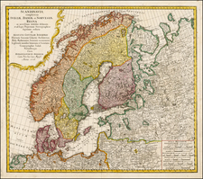
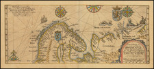
Impressive two-sheet engraved antique map of Scandinavia, published by the 17th century London mapmaker William Berry in 1684.
The map covers all of Scandinavia, the Baltic Countries, and a large part of northwestern Russia.
In 1684, the dominant power in Scandinavia was the Swedish Empire, which lasted from 1611 to 1721. This is indicated by the long label "States of the Crown of Sweden" which stretches through Finland to modern-day Estonia.
The map was issued in three known states, this being the first.
The map is dedicated to King Charles II, who ruled England until his death in 1685. Many of Berry's pre-1685 maps are dedicated to Charles II.
Many of Berry's maps are derived from Sanson via Jaillot and the same is true of this map.
Condition Description
Two sheets joined as one. Scant original outline hand-color. Minro toning and wear at the centerfold.