|
||

|

|
|

|
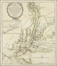
Impressive, and surprisingly scarce, lithographed map of Manhattan issued by the eminent New York City mapmakers G.W. & C.B. Colton & Co.
The map covers the entirety of Manhattan, with the city blocks and Central Park laid out, and built-up areas indicated with shading. The main north-south Manhattan thoroughfares are illustrated in blue and pink hand-coloring.
As of the making of the map, the city was sparsely built-up north of 34th Street, with the exceptions of Yorkville and Harlem. Sections of Queens, including Astoria, Hunters Point, and Ravenswood and illustrated. In Brooklyn parts of Greenpoint, Williamsburg, and Brooklyn Heights are depicted. Jersey City and Hoboken make the top of the map.
Rarity
OldMaps records not a single example, and, other than the present example, nor does RBH. OCLC records only three examples: NYHS, Harvard, and the British Library.
G. W. & C. B. Colton was a prominent family firm of mapmakers who were leaders in the American map trade in the nineteenth century. The business was founded by Joseph Hutchins Colton (1800-1893) who bought copyrights to existing maps and oversaw their production. By the 1850s, their output had expanded to include original maps, guidebooks, atlases, and railroad maps. Joseph was succeeded by his sons, George Woolworth (1827-1901) and Charles B. Colton (1831-1916). The firm was renamed G. W. & C. B. Colton as a result. George is thought responsible for their best-known work, the General Atlas, originally published under that title in 1857. In 1898, the brothers merged their business and the firm became Colton, Ohman, & Co., which operated until 1901, when August R. Ohman took on the business alone and dropped the Colton name.
![[Brooklyn] The Anderson T. Herd Realty Co's Map of the Borough of Brooklyn & Part of Queens with Present & Projected Transit Lines, Elevated & Surface Railways, Bridges, Tunnels & Subways . . . 1906](https://storage.googleapis.com/raremaps/img/small/84230.jpg)