This item has been sold, but you can enter your email address to be notified if another example becomes available.


|
||

|

|
|

|
Stock# 71083
Description
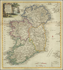
Engraved antique map of Ireland, engraved by J.B. Tardieu, and published by Conrad Malte-Brun in Paris, 1812.
In the map, Ireland is divided into Connaught, Ulster, Linster, and Munster.
The cartouche in the bottom-right features the columnar basalt of the Giant's Causeway in County Antrim.
![[Ireland / Sea Chart] Carte des Cotes Occidentales D'Irlande Reduite de la Carte de Stuart Amos Arnold et rectifee d'apres les Plans leves par M. MacKenzie Publiee Par ordres du Contr-amiral Decres Ministre de Marine et des Colonies . . . 1803](https://storage.googleapis.com/raremaps/img/small/63682.jpg)
![[Siege of Dunboy] Bere Island](https://storage.googleapis.com/raremaps/img/small/83706.jpg)
![Johnson's Ireland [with] Johnson's Scotland](https://storage.googleapis.com/raremaps/img/small/78184.jpg)
![[ Ireland ] Hiberniae Regnum tam in praecipuas Ultoniae, Connaciae, Lageniae, et Momoniae. . .](https://storage.googleapis.com/raremaps/img/small/78023.jpg)