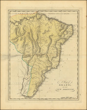
|
||

|

|
|

|
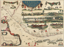
Engraved map of the Bahia De Todos Sanctos in Brazil, published by Matthias Merian in Frankfurt in 1635.
The map shows the Bahia De Todos Sanctos with many settlements surrounding it. In the lower-left corner is an inset plan of São Salvador da Bahia de Todos os Santos, with an 18-point key to important local landmarks.
In the late 1630s, Holland attempted to reassert its claim over Brazil by establishing a series of forts along the coastline. One of the best-documented colonies was the expedition led by Prince Maurits of Nassau, who attempted to assemble an intellectual court in the New World. He brought with him a group of highly accomplished artists, mapmakers, and scientists to record the mysteries of Brazil. Known as Sao Salvador, or Bahia, the town was first founded by the Portuguese in 1549 and was a favorite haunt for pirates and merchant privateers. The town flourished with the development of the sugar plantations and became an important political and economic center.
The map was copied by the Blaeu firm in their Atlas Maior.
Mathaus Merian (1593-1650) was the father of engraver Matthäus the Younger, and of the painter, engraver, and naturalist Maria Sibylla Merian. He was born in Basel, Switzerland and trained in engraving in Zurich. After a time in Nancy, Paris and Strasbourg, he settled in Frankfurt. While there, he worked for Johann Theodor de Bry, the publisher and son of the travel writer. In 1617, he married Maria Magdalena de Bry, Johann Theodor’s daughter. In 1623, Merian took over the de Bry publishing house upon the death of his father-in-law. Merian’s best known works are detailed town views which, due to their accuracy and artistry, form a valuable record of European urban life in the first half of the sixteenth century
![A collection of five watercolor drawings from the Luso-Hispanic Border Commission in the Amazon Basin, drawn by its Spanish commanding officer: Parte del camino de tierra de Quito al R. Napo (Lamina I); Vista de la Poblacion y Fortaleza de S. Fran[is]co Xavier de Tabatinga (Lamina V); Vista del Salto grande del Rio Yapurà desde la dist.a de 3 Leguas (Lamina X); Vista del Grande Salto inaccesible del Rio Yapurá (Lamina XI); Los Pongos del Rio Marañon [Lamina XVIII].](https://storage.googleapis.com/raremaps/img/small/100698.jpg)