


|
||

|

|
|

|
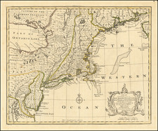
Striking full hand-color example of the first edition David Burr's map of New York, which appeared in his Universal Atlas, first issued in 1836.
A highly detailed map, owing undoubtedly to Burr's prior New York Atlas and separate county pocket maps, which he had begun publishing in the 1820s. Shows towns, rivers, roads, railroads, canals, lakes, islands, and substantial other detail. Large inset of Long Island and the New York City area. One of the scarcest atlas maps of New York issued during the period. Burr's Atlas was perhaps the most elegant American commercially published atlas of its time, utilizing wonderful wash colors and elegant engraving style. Burr studied under Simeon DeWitt in New York. His first atlas was an Atlas of New York State, the second state atlas to be issued in the US (after Mills Atlas of South Carolina in 1826).
In the 1830s, Burr served as topographer for the US Post Office, producing a series of rare and highly sought after large format state maps during this period. Later, he was appointed as the Geographer of the House of Representatives, where he served during the later part of the 1830s. Burr is widely regarded as one of the most important names in American Cartographic history.
David H. Burr studied law, passing the New York Bar Exam, and then surveying under Simeon DeWitt in New York. His first atlas was an atlas of New York State (1829), the second state atlas to be issued in the US (after Mills’ Atlas of South Carolina in 1826). In the 1830s, he served as the official topographer for the US Post Office, producing a series of rare and highly sought-after large-format state maps. He also created a map of the country’s postal routes, which features roads, canals, and railroads. Burr traveled to London to work with John Arrowsmith; together, they produced the American Atlas in 1839.
Upon his return to the States, Burr was appointed as a draftsman for the House of Representatives, where he worked until ca. 1841. He later worked for the Louisiana Survey and the Florida Survey. By 1850, he was back in Washington D. C., working on the census. In 1852, the Senate named Burr as the draftsman to compile maps from the Federal Surveys. In 1853, Burr traveled to San Francisco, perhaps as part of his work for the Senate. He was then named as the Surveyor General of Utah in 1855. However, he was unpopular there and returned to Washington D. C. by 1870. Burr is widely regarded as one of the most important names in the nineteenth-century American history of cartography.
![(New York-Robert C. Livington) [Revolutionary-Era Land Indenture]](https://storage.googleapis.com/raremaps/img/small/91957.jpg)
![[ Battle of Saratoga ] Plan of the Position which the Army under Lt. Gen. Burgoine took at Saratoga on the 10th of September 1777 and in which it remained till the Convention was signed.](https://storage.googleapis.com/raremaps/img/small/101239.jpg)
![[ Battle of Saratoga with extra flap ] Plan of the Encampment and Position of the Army under His Excelly. Lt. General Burgoyne at Swords House on Hudson's River near Stillwater on Septr. 17th with the Positions of that part of the Army engaged on the 19th Septr. 1777. Drawn by W.C. Wilkinson Lt. 62d. Regt. Asst. Engr. . . .](https://storage.googleapis.com/raremaps/img/small/100140.jpg)