


|
||

|

|
|

|
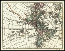
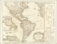
Scarce Second State of Abraham Ortelius' Map of the Americas, One of the Most Iconic Maps of the Western Hemisphere
Orteliu's map of America is without doubt one of the most recognized and influential maps of the Americas from the sixteenth century and had a profound influence on contemporary cartography.
The present example is the second edition of the map, first issued in 1579. This is the first issue of the second edition, with a remarkably dark and clear impression.
Ortelius' went through three major revisions to the plates between 1570 and 1612, along with an impossibly rare fourth state, issued separately after 1620, several decades after Ortelius's death.
North and South America stretch across this single hemisphere map. To the north, North America somewhat resembles the continent we know today, except the area near Alaska is undefined and the northwest bulges to the east. South America is a squat landmass, early editions have an extension in the southwest that would disappear in later editions of the map.
The title is decorated with the key-like geometric decorations common to the maps in Ortelius' atlas. In the ocean, a sea monster lurks. In the Pacific, ships stream through the water, their sails filled with imaginary winds.
The Straits of Magellan separate South America from a large southern continent that extends all the way to New Guinea. Tierra del Fuego, named by Magellan because he saw so many small fires burning there, is part of this continent. The name "Novae Guinea", or New Guinea, was coined by Spanish explorer Íñigo Ortíz de Retes in 1545, and it refers to his opinion that the appearance of the native peoples resembled the natives of the Guinea region of Africa.
Two place names in the northwest of North America are particularly interesting. Anian derives from Ania, a Chinese province on a large gulf mentioned in Marco Polo's travels (ch. 5, book 3). The gulf Polo described was actually the Gulf of Tonkin, but the province's description was transposed from Vietnam to the northwest coast of North America. The first map to do was Giacomo Gastaldi's world map of 1562, followed by Zaltieri and Mercator in 1567. The Strait then became shorthand for a passage to China, i.e. a Northwest Passage. It appeared on maps until the mid-eighteenth century.
Quivira refers to the Seven Cities of Gold sought by the Spanish explorer Francisco Vasquez de Coronado in 1541. In 1539, Coronado wandered over what today is Arizona and New Mexico, eventually heading to what is now Kansas to find the supposedly rich city of Quivira. Although he never found the cities or the gold, the name stuck on maps of southwest North America, wandering from east to west.
Ortelius' ability to locate and draw upon both Spanish and Portuguese sources is apparent throughout the map, and is quite remarkable, given the manner in which each nation guarded its cartographic information. Both nations kept their geographic knowledge locked in a single institution, with all cartographic knowledge maintained on a single master map. Copies of the master map were closely monitored and pilots could be punished for not returning their charts; however, no vault is impenetrable and geographic secrets leaked out, including to Ortelius in Antwerp.
Ortelius' Atlas and the states of Americae Sive/Novi Orbis
The influence of this and other Ortelius maps stems from the popularity and dominance of his atlas in the European market. In 1570, Ortelius published the first modern atlas; that is, a set of uniform maps with supporting text gathered in book form. Previously, there were other bound map collections, specifically, the Italian Lafreri atlases, but these were sets of maps-not necessarily uniform-selected and bound together on demand.
Theatrum Orbis Terrarum, Ortelius' atlas, outperformed competing atlases from other cartographic luminaries like the Mercator family. Between 1570 and 1612, 31 editions of the atlas were published in seven languages. This map, in its first edition, appeared in the very first 1570 atlas.
States of the Map
The map is known in four editions (involving 3 different copperplates):
- First Edition: 1570-1575 (bulge the southern part of South America)
- Second Edition: 1579-1587 (larger ships in the Pacific, the largest sailing west, not east)
- Third Edition: 1587-1612 (bulge in South America removed)
- Fourth Edition: Separately published after 1620 (Strait of Le Maire added, 1587 date removed). Published using the same copperplate as the Third Edition.
Abraham Ortelius is perhaps the best known and most frequently collected of all sixteenth-century mapmakers. Ortelius started his career as a map colorist. In 1547 he entered the Antwerp guild of St Luke as afsetter van Karten. His early career was as a business man, and most of his journeys before 1560, were for commercial purposes. In 1560, while traveling with Gerard Mercator to Trier, Lorraine, and Poitiers, he seems to have been attracted, largely by Mercator’s influence, towards a career as a scientific geographer. From that point forward, he devoted himself to the compilation of his Theatrum Orbis Terrarum (Theatre of the World), which would become the first modern atlas.
In 1564 he completed his “mappemonde", an eight-sheet map of the world. The only extant copy of this great map is in the library of the University of Basel. Ortelius also published a map of Egypt in 1565, a plan of Brittenburg Castle on the coast of the Netherlands, and a map of Asia, prior to 1570.
On May 20, 1570, Ortelius’ Theatrum Orbis Terrarum first appeared in an edition of 70 maps. By the time of his death in 1598, a total of 25 editions were published including editions in Latin, Italian, German, French, and Dutch. Later editions would also be issued in Spanish and English by Ortelius’ successors, Vrients and Plantin, the former adding a number of maps to the atlas, the final edition of which was issued in 1612. Most of the maps in Ortelius' Theatrum were drawn from the works of a number of other mapmakers from around the world; a list of 87 authors is given by Ortelius himself
In 1573, Ortelius published seventeen supplementary maps under the title of Additamentum Theatri Orbis Terrarum. In 1575 he was appointed geographer to the king of Spain, Philip II, on the recommendation of Arias Montanus, who vouched for his orthodoxy (his family, as early as 1535, had fallen under suspicion of Protestantism). In 1578 he laid the basis of a critical treatment of ancient geography with his Synonymia geographica (issued by the Plantin press at Antwerp and republished as Thesaurus geographicus in 1596). In 1584 he issued his Nomenclator Ptolemaicus, a Parergon (a series of maps illustrating ancient history, sacred and secular). Late in life, he also aided Welser in his edition of the Peutinger Table (1598).
![Nov. Orbis sive America Septentrionalis . . [California as an Island]](https://storage.googleapis.com/raremaps/img/small/67439.jpg)