|
||

|

|
|

|
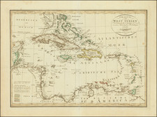
From the Survey of George Gauld and others -- One of the Rarest De Barres Sea Charts
Very large hand-colored engraved chart of the coast of the Gulf of Mexico covering parts of the present-day states of Florida, Louisiana, Alabama, and Mississippi.
In the east, the map extends as far as Pensacola Bay, where soundings are given and the cities of Pensacola and Campbell Town are illustrated. In the west, the cartography is less precise, but the map extends beyond Vermillion Bay and Lafayette.
In Alabama, the map covers all of Mobile Bay, with the city of Mobile shown at the upper end. On the interior there is substantial coverage of creeks and rivers, especially those that feed into Mobile Bay. The extends north of the juncture between the Mobile and Alabama Rivers, here called "Mobile or Tombecbe Riv." and "Coosa or Alibama Riv."
In Louisiana, there is fairly good detail east of the Mississippi Delta, with dozens of soundings recorded, as well as island names and anchorages. West of the Mississippi, the mapping becomes less reliable, an indication of the difficulty that centuries of surveyors had with that region.
Though the neatline and graticulated border are unbounded at the right edge - making it appear that the map was intended to be completed with a further eastern sheet - the map was only ever issued as we have it here; two sheets joined as one. In later states, an engraved eastern border was added, as one can see in this example from the National Maritime Museum: collections.rmg.co.uk/collections/objects/560782.html
The map information is likely drawn from George Gauld
George Gauld
Following the French & Indian War, George Gauld, a Scottish surveyor, was assigned the task of charting the waters off the Gulf Coast of West Florida. Between 1764 and 1781 Gauld mapped an area that extended from New Orleans to the western coast of modern-day Florida. Recognizing the importance of his work to all those who traveled in the area, Gauld readily shared his work with scientific societies in America, including the American Philosophical Society in Philadelphia.
During the Revolutionary War, Gauld was forced to suspend his work in the Dry Tortugas and the Florida Keys due to attacks by American privateers, and in 1781, he was taken prisoner at the Siege of Pensacola. Gauld was subsequently taken to Havana and then New York, before being repatriated to England, where he died shortly afterward. The following is an excerpt from John D. Ware and Robert R. Rea's book on Gauld describing his relationship with the chart:
...It is clear that his examination and charting of Pensacola Bay and environs was completed before May 4, 1766, the date Governor Johnstone sent the "Plan of the Bay" to the Board of Trade.
Taken together, these manuscript drawings formed the basis for the only known work by George Gauld published during his lifetime, A Chart of the Bay and Harbour of Pensacola, in J.F.W. Des Barres's Atlantic Neptune in 1780. Gauld's Chart demonstrates that he surveyed the lagoons of the north and west shores of lower Pensacola Bay with great care. On the Chart, Gauld's earlier designation of "Large Lagoon" became "Grand Lagoon"; his "Lagoon" was christened "Cox's Lagoon"; the unnamed inlet, of which only the mouth was shown earlier, appeared as "West Lagoon"; and his "Salt River" was changed to "East Lagoon". The tributary streams were drawn and shaded in such a manner as to indicate the topography of the land. North and west of Pensacola six lakes were described, further indicating the extent to which Gauld surveyed the surrounding countryside. Modern Escambia, Blackwater, and East bays were examined and charted to their headwaters. The Escambia River was called "Scambia," but the bay itself remained unnamed. From English Point northward, "Hull" and "Stony Points," now known as Devil and Lora points, were identified, and a "Brickkiln" was located just south of the latter promontory. The only other village on the bay, Campbell Town, was identified and located about one mile south of the mouth of the Escambia River. Present Mulatto and Indian bayous were sketched but left unnamed, while the southern extremity of the peninsula, now terminating in Hernandez, Garcon, and White points, was labeled "Yemassee Point". Blackwater Bay retained his Indian and English names of "Oyuva Lana or Yellow River." Unaccountably, Gault's former "East Point" was changed to "Fan Point" in the published version of his work.
The "Remarks" on Gauld's earlier "Plan" were slightly abbreviated, and the Chart was drafted to a smaller scale by Des Barres; coordinates of latitude and longitude were provided in the margins, though both were somewhat in error. Two compass roses were printed, and the magnetic variation was again given as 4°30' E. Some eighty tracts of land of various sizes and shapes were depicted on Des Barres's version, exclusive of the lots comprising the villages of Pensacola and Campbell Town. Finally, it should be noted that comparisons of Gauld's earlier manuscript drawings and published charts with their modern counterparts disclose amazing similarities as to distances and configurations, a striking demonstration of Gauld's skill as a marine surveyor--and the remarkably few significant changes wrought by man or nature in the intervening period of more than two centuries.
States of the Map
There are two known states:
- First State: Lacking double ruled line at right edge of map.
- Second State: Adding double ruled line.
Rarity
This chart is of the utmost rarity. We note only 1 example in a dealer catalog in the past 30 years (Arkway 1994, Catalog 43, #58), which is likely this example (see below).
Provenance: Morphy Auctions, November 17, 2020 (Lot 1210); Neal Auctions September 11, 2010 (Lot 200 -- Sold for $22,705).
Joseph Frederick Wallet Des Barres (1721-1824) was born in either Paris or Basel, Switzerland, to a Hugueont family. He studied under the great mathematician Daniel Bernoulli at the University of Basel before immigrating to Britain, where he trained at the Royal Military College, Woolwich.
Upon the outbreak of hostilities with France in 1756, he joined the British Royal American Regiment as a military engineer. He came to the attention of General James Wolfe, who was impressed with his charting ability. During this period, he also worked with the legendary future explorer, James Cook, on a monumental chart of the St. Lawrence River.
Des Barres is best known for the Atlantic Neptune, was a remarkable, multi-volume set of sea charts and coastal views prepared from recent surveys, some of which were overseen by Des Barres in Nova Scotia after the Seven Years’ War. The maps, charts, and views were prepared under the supervision of Des Barres and employed as many as twenty engravers and assistants. They were produced over the course of a decade, from 1774 to 1784, in time to be used by the Royal Navy in the American Revolution.
After the Revolution, Loyalists were resettled throughout Canada. As part of this process, a new colony was created by separating Cape Breton from Nova Scotia. Des Barres, who already owned extensive lands in the Maritimes, served as lieutenant governor of Cape Breton Island from 1784 to 1787. He later served as governor of Prince Edward Island from 1804-1812.
Des Barres lived an exceptionally long life, even by today's standards, finally dying at age 102. Des Barres' funeral was held at St. George's Round Church in 1824 and he is buried in Halifax.
![(Florida-Georgia) Wie der Franzosen Oberster eine Seul / daran das Wapen dess Königes auss Franckreich / aussrichten lassen. [How the French commander had a seal made, on which the coat of arms of the King of France is displayed.]](https://storage.googleapis.com/raremaps/img/small/95828.jpg)
![County Map of Florida [with Maps of North & South Carolina and inset of Charleston]](https://storage.googleapis.com/raremaps/img/small/92536.jpg)